
 4 months ago
99
4 months ago
99
PROTECT YOUR DNA WITH QUANTUM TECHNOLOGY
Orgo-Life the new way to the future Advertising by AdpathwayDisclaimer: This site is not affiliated with the National Hurricane Center, Hurricane Hunters, Storm Prediction Center, or National Weather Service. ALL forecasts herein are the result of my analysis, (to which you will see me at times, insert excerpts from various agencies due to the nature of the importance of the information) and I am solely responsible for the content. As ALWAYS, follow the National Hurricane Center, National Weather Service, and your local Emergency Management officials for emergency decisions. In addition, this is strictly a FORECAST OFFICE. I CANNOT make decisions regarding travel plans, etc. My purpose, is to provide you the information, based solely on information I analyze, and the accuracy of the information at hand of the time of analysis, so you may make informed decisions.
(T. F. “Storm” Walsh)
For those who have donated to my site, your help has been greatly appreciated. If you are not aware, donations to my site help pay for subscriptions to sites I use as well as software updates, which provide all the models and information used in my forecasts. To donate, please click the DONATE button to the right side of the page, or on the graphic of the dog. Any help you provide is immensely appreciated!
DONATIONS ACCEPTED AND APPRECIATED


I will reiterate, my forecasts are based on the available information at the time of analysis, and are only as accurate as the information analyzed and the solutions provided.
Good day everyone!
The forecast center is closed on Sunday’s. However given the probable seriousness of the SPC update from ENHANCED to MODERATE risk, I thought it good to do a quick post. This will not be a full synopsis, but more of a severe weather “statement”.
For residents under the significant hatched areas, PLEASE read the SPC outlook linked in the SPC outlook graphic. I intend to put out a full synopsis tomorrow as soon as I possibly can.
The Storm Prediction Center has upgraded and issued a MODERATE risk for severe thunderstorms in the current DAY 2 outlook: IN PARTS OF SOUTH CAROLINA…NORTH CAROLINA…VIRGINIA…MARYLAND…AND WASHINGTON D.C…
The current DAY 2 MODERATE risk includes SIGNIFICANT HATCHED areas.
…SPC SUMMARY…
Widespread severe storms are anticipated on Monday across the Southeast and Mid-Atlantic States. Tornadoes, some strong, and particularly damaging winds are most likely from parts of South Carolina to Maryland during the afternoon.
1730Z SPC DAY 2 SEVERE THUNDERSTORM OUTLOOK (LINKED FOR OUTLOOK TEXT)
TORNADO PROBABILITY
Probability of a tornado within 25 miles of a point. Hatched Area: 10% or greater probability of EF2 – EF5 tornadoes within 25 miles of a point.
HAIL PROBABILITY
Probability of one inch diameter hail or larger within 25 miles of a point. Hatched Area: a 10% or greater probability of 2-inch diameter or larger hail within 25 miles of a point
DAMAGING THUNDERSTORM WIND PROBABILITY
Probability of damaging thunderstorm winds or wind gusts of 50 knots or higher within 25 miles of a point. Hatched Area: a 10% or greater probability of 65 kt+ winds within 25 miles of a point.
CSU – MLP DAY 2 PROBABILITY (CLICK FOR LARGER IMAGE)
NSSL ML DAY 2 PROBABILITY

DAY 2 PROBABILITY CONVERSION TABLE
SPC DISCUSSION:
…East…
No change has been made to the ongoing level 4-MDT risk, with some expansion of the 3-ENH in GA, as well as expansions of 1-2/MRGL–SLGT across NY and FL. The highly meridional deep-layer flow regime suggests that surface-based instability appears more likely to develop into NY on Monday afternoon. This type of flow regime, along with substantial early-day convection south, both render some uncertainty on intensity amplitudes for wind/tornado across much of the ENH–MDT risk areas.
A broken band of pre-frontal convection should be ongoing at 12Z Monday from the lee of the southern Appalachians to the FL Panhandle. The downstream environment will already be favorable for supercells including strong tornado potential. With mid to upper 60s surface dew points and initially modestly steep mid-level lapse rates, a plume of moderate buoyancy with MLCAPE of 1000-2000 J/kg should diurnally expand from north FL through at least SC. Any semi-discrete supercells in this environment will have the potential to produce a strong tornado and large hail through early afternoon before large-scale outflow likely shifts offshore of the GA/north FL coast.
Destabilization farther north from NC to the DE Valley appears more uncertain, with potential for near-coastal convection within the low-level warm conveyor limiting more expansive/robust boundary-layer heating. A plume of weak MLCAPE up to 1000 J/kg should still develop across the Piedmont into parts of the coastal plain. Although flow fields will be highly meridional, they will be quite strong with an intense 700-mb jet strengthening across the Southeast behind the surface cold front. This will yield enlarged low-level hodograph curvature across much of the pre-frontal warm-moist sector.
Even weak boundary-layer heating will be sufficient for intensification of an extensive QLCS from western to central portions of NY/PA southward through VA/NC towards midday/early afternoon. Embedded supercell structures should be most pronounced south, where breaks in the QLCS are more probable. Some of these could be long-track with sporadic strong tornadoes, in addition to the background widespread damaging winds anticipated with the QLCS. This activity will eventually interact with cool trajectories near the coastal Atlantic and should result in waning of severe potential in the Northeast near sunset.
Based on some preliminary data from the NAM 3km model, and the current SPC outlook / graphics, the strongest threat at the moment appears to be the possibility of strong tornadoes, with a possible isolated intense (EF4 – EF5) tornado probability, and significant damaging thunderstorm winds / gusts. I have not posted forecast indices, as these will surely update in the overnight and early morning runs. This situation could pose an isolated PDS (Particularly Dangerous Situation) over the 15% HATCHED TORNADO outline.
Again, I will try to post an update tomorrow as soon as possible. I highly recommend that residents within the risk areas review their tornado safety plans.
The following NWS Watch / Warning map will provide local NWS information for your area. Click the image, then once it refreshes, click on your area of interest to view forecasts, any special weather statements, hazards or advisories for your area.
NWS WATCH / WARNING DISPLAY (LINKED…CLICK MAP, THEN YOUR AREA)
NWS DOPPLER RADAR LOOP (LINKED, CLICK RADAR MAP)
RAP RADAR (CLICK IMAGE THEN GO TO LOOP DURATION AND PICK LENGTH OF LOOP, THEN CLICK RADAR SITE)
WUNDERGROUND RADAR SUMMARY MAP (CLICK FOR UPDATES)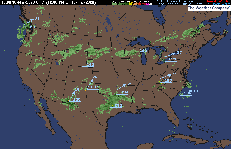
PRECIPITATION TYPE (CLICK TO ACCESS ANIMATION FEATURE)
CARIBBEAN RADAR (CLICK IMAGE TO ACCESS ANIMATION)
You may direct any questions by contacting me personally, ANYTIME, at: [email protected]
Have a blessed day!
T. F. “STORM” WALSH III
GMCS, USCG (ret)
METEOROLOGIST / HURRICANE SPECIALIST /SEVERE WEATHER SPECIALIST


 English (US) ·
  French (CA) ·