
 6 months ago
168
6 months ago
168
PROTECT YOUR DNA WITH QUANTUM TECHNOLOGY
Orgo-Life the new way to the future Advertising by AdpathwayDisclaimer: This site is not affiliated with the National Hurricane Center, Hurricane Hunters, Storm Prediction Center, or National Weather Service. ALL forecasts herein are the result of my analysis, (to which you will see me at times, insert excerpts from various agencies due to the nature of the importance of the information) and I am solely responsible for the content. As ALWAYS, follow the National Hurricane Center, National Weather Service, and your local Emergency Management officials for emergency decisions. In addition, this is strictly a FORECAST OFFICE. I CANNOT make decisions regarding travel plans, etc. My purpose, is to provide you the information, based solely on information I analyze, and the accuracy of the information at hand of the time of analysis, so you may make informed decisions.
(T. F. “Storm” Walsh)
For those who have donated to my site, your help has been greatly appreciated. If you are not aware, donations to my site help pay for subscriptions to sites I use as well as software updates, which provide all the models and information used in my forecasts. To donate, please click the DONATE button to the right side of the page, or on the graphic of the dog. Any help you provide is immensely appreciated!
DONATIONS ACCEPTED AND APPRECIATED


I will reiterate, my forecasts are based on the available information at the time of analysis, and are only as accurate as the information analyzed and the solutions provided.
Good day everyone!
Just to reiterate, though some of my forecasts may not directly apply to you, I have no idea where your families or friends reside, and is the reason you may receive the forecasts.
The Storm Prediction Center (SPC) has issued a MARGINAL risk for severe thunderstorms in the current DAY 3 Outlook: IN THE SOUTHEAST AND NORTHERN CA TO COASTAL SOUTHWEST OR…
…SPC SUMMARY…
Isolated severe storms are possible across parts of the Southeast on Saturday, and the Sacramento Valley to coastal northern California-southwest Oregon during the late afternoon to evening.
SPC DAY 3 SEVERE THUNDERSTORM OUTLOOK (LINKED FOR OUTLOOK TEXT)

The following is the day 3 outlook from the CSU – MLP severe weather forecast map vs the SPC forecast, and the NSSL ML day 3 severe probability with both indicating a possible upgrade to a slight risk outline:
CSU – MLP DAY 3 FORECAST (CLICK FOR LARGER IMAGE)
NSSL DAY 3 SEVERE FORECAST PROBABILITY (LINKED)

DAY 3 PROBABILITY CONVERSION TABLE
SPC DISCUSSION EXCERPT:
…Southeast…
A lower-amplitude shortwave trough should progress east across the Lower MS Valley on Saturday morning and off the South Atlantic Coast by Saturday night. Attendant surface cyclone should remain weak and track from central AL to off coastal SC by evening. Timing of large-scale ascent with the trough should yield increasing convective coverage by late morning to midday, focused along the northeast Gulf Coast to the Savannah Valley. Much of the region should remain within the MLCAPE gradient as a plume of moderate buoyancy becomes established over the northwest Gulf to central Gulf Coast. Guidance consensus suggests that low-level winds may gradually dampen through the day and become displaced east of richer boundary-layer moisture as the surface low moves towards the coast. With a predominately west-southwesterly wind profile, deep-layer speed shear should be the primary driver of organized convection. A mix of all hazards appears plausible, although a corridor of greater damaging wind potential may be evident in later outlooks.
Based on analysis of some severe forecast indices and parameters this afternoon, the atmosphere is currently forecast to be marginally unstable. The current forecast indices indicate weak mid level lapse rates at around 6.0 – 6.5 C/km. Forecast lifted indices indicate marginal instability, ranging from -1 to -3. SBCAPE is currently forecast between 250 – 1250 J/kg-1, and MLCAPE 250 – 750 J/kg-1. All severe hazards appear to be somewhat possible for Saturday. IF any tornado and hail activity do occur, I currently expect it to be weak. I intend on providing an updated forecast with severe indices and parameters tomorrow, and will try to provide a DAY 1 outlook on Saturday with indices as well.
NADOCAST forecast maps will not be available as they are only issued for the Day 1 severe weather events. I will not be available on Sunday for the Day 1 outlook.
Although the following is in the longer range forecast, the CSU – MLP and NSSL ML forecasts indicate a possibility of severe weather on Thursday, JAN. 08, and the NSSL ML indicating a stronger probability on Friday, JAN. 09. I am only mentioning the longer range, as I have noticed the ML based programs have been doing a decent job in predicting the severe weather probs. Based on how parameters can change in the longer term, I would just consider this as a heads up update to make residence somewhat aware. I will continue to monitor this as the week progresses.
CSU – MLP DAY 8 FORECAST (CLICK FOR LARGER IMAGE)
NSSL DAY 8 SEVERE FORECAST PROBABILITY (LINKED)
NSSL DAY 9 SEVERE FORECAST PROBABILITY
The following links will connect you to the Excessive Rainfall probabilities and River Flood Outlook:
EXCESSIVE RAINFALL
https://www.wpc.ncep.noaa.gov/qpf/excessive_rainfall_outlook_ero.php
SIGNIFICANT RIVER FLOOD OUTLOOK
https://www.wpc.ncep.noaa.gov/nationalfloodoutlook/index.html
The following NWS Watch / Warning map will provide local NWS information for your area. Click the image, then once it refreshes, click on your area of interest to view forecasts, any special weather statements, hazards or advisories for your area.
NWS WATCH / WARNING DISPLAY (LINKED…CLICK MAP, THEN YOUR AREA)
NWS DOPPLER RADAR LOOP (LINKED, CLICK RADAR MAP)
RAP RADAR (CLICK IMAGE THEN GO TO LOOP DURATION AND PICK LENGTH OF LOOP, THEN CLICK RADAR SITE)
WUNDERGROUND RADAR SUMMARY MAP (CLICK FOR UPDATES)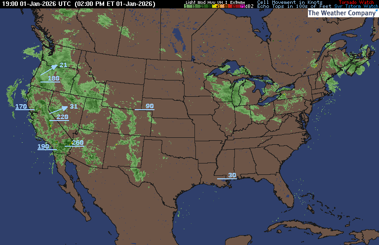
PRECIPITATION TYPE (CLICK TO ACCESS ANIMATION FEATURE)
CARIBBEAN RADAR (CLICK IMAGE TO ACCESS ANIMATION)
You may direct any questions by contacting me personally, ANYTIME, at: [email protected]
Have a blessed day!
T. F. “STORM” WALSH III
GMCS, USCG (ret)
METEOROLOGIST / HURRICANE SPECIALIST /SEVERE WEATHER SPECIALIST


 English (US) ·
  French (CA) ·