
 3 months ago
112
3 months ago
112
PROTECT YOUR DNA WITH QUANTUM TECHNOLOGY
Orgo-Life the new way to the future Advertising by AdpathwayDisclaimer: This site is not affiliated with the National Hurricane Center, Hurricane Hunters, Storm Prediction Center, or National Weather Service. ALL forecasts herein are the result of my analysis, (to which you will see me at times, insert excerpts from various agencies due to the nature of the importance of the information) and I am solely responsible for the content. As ALWAYS, follow the National Hurricane Center, National Weather Service, and your local Emergency Management officials for emergency decisions. In addition, this is strictly a FORECAST OFFICE. I CANNOT make decisions regarding travel plans, etc. My purpose, is to provide you the information, based solely on information I analyze, and the accuracy of the information at hand of the time of analysis, so you may make informed decisions.
(T. F. “Storm” Walsh)
Thanks to all of you that still follow my forecasts. I truly appreciate each and every one of you!
For those who have donated to my site, your help has been greatly appreciated. If you are not aware, donations to my site help pay for subscriptions to sites I use as well as software updates, which provide all the models and information used in my forecasts. To donate, please click the DONATE button to the right side of the page, or on the graphic of the dog. Any help you provide is immensely appreciated!
DONATIONS NEEDED AND APPRECIATED


I will reiterate, my forecasts are based on the available information at the time of analysis, and are only as accurate as the information analyzed and the solutions provided.
Good day everyone!
The forecast office is closed on Sunday.
The SPC currently indicates the probability for a SLIGHT severe weather risk for Saturday (DAY 6) and Sunday (DAY 7)
SPC DAY 6 PROBABILITY (LINKED)

SPC DAY 7 PROBABILITY (LINKED)

The Storm Prediction Center has issued a MARGINAL severe weather risk in their DAY 3 severe weather outlook: ACROSS PARTS OF THE CENTRAL PLAINS…
…SPC SUMMARY…
Thunderstorms with isolated large hail will be possible in parts of the central Plains Wednesday night.
STORM PREDICTION CENTER (SPC) DAY 3 SEVERE WEATHER OUTLOOK (LINKED)

 NADOCAST maps will not be available until the SPC DAY 1 outlook.
The following are the current CSU – MLP and NSSL – ML severe weather guidance forecast maps for DAY3:
CSU – MLP DAY 3 SEVERE WEATHER PROBABILITY MAPS (CLICK FOR LARGER IMAGE)


NSSL – ML DAY 3 SEVERE WEATHER PROBABILITY MAP

CSU – MLP 6 PANEL PROBABILITIES DAY 1 AND DAY 2 (CLICK FOR LARGER IMAGE)


DAY 3 PROBABILITY CONVERSION TABLE

SPC DISCUSSION EXCERPT:
…Central Plains…
An upper-level trough will move eastward across the north-central U.S. on Wednesday, as low-level moisture advection takes place in the southern and central Plains. At the surface, a cold front from will advance southward into the central Plains. By Wednesday evening, the front is forecast to stall over northern Kansas, with scattered thunderstorms developing near and to the northern boundary. NAM forecast soundings in the vicinity of the front late Wednesday evening have a low-level temperature inversion with MUCAPE near 1200 J/kg. 700-500 mb lapse rates are forecast around 8 C/km with effective shear near 40 knots. This environment should support a threat for isolated large hail with elevated supercells. The threat may continue into the overnight period, as a low-level jet strengthens.
I will continue to monitor the updates of the SPC outlooks for any changes, and intend to update as possible during the week.
Given that analysis is for indices greater than 24 hours out in the forecast period, the following should not be considered absolute, as guidance will most likely change over the next few days.
The NAM 3km model current severe indices and parameters indicate at the moment a MARGINALLY unstable atmosphere on Wed.
NAM SBCAPE (SURFACE BASED CONVECTIVE AVAILABLE POTENTIAL ENERGY) FORECAST

NAM DEW POINT FORECAST
 This current forecast setup indicates the main / strongest severe threat to be isolated large hail, amidst a very dry atmosphere based on current forecast dew points. Strongest indices appear to be located within the darkest shading in the NSSL ML probability forecast map. Based on current forecast indices, a tornado risk does not appear likely at this time.
Indices were analyzed from the NAM 3KM, HRRR 3KM, CIPS DETERMINISTIC, and SPC SREF model guidance.
REGARDING EHI VALUES: While EHI values are calculated utilizing MLCAPE and 0 – 3 km SRH values (MLCAPE x 0 – 3 km SRH /160,000), the highest SRH values do not always fall within ample, highest MLCAPE values for the best probability of tornado activity. I utilize the SRH and MLCAPE values over the area that may have the most likely tornado potential. Maximum EHI values are calculated within the area(s) that have the greatest probability for tornado activity.
The following were the forecast parameters and indices analyzed this morning. Bear in mind, MAXIMUM indices recorded below are for the time of peak intensity. Some indices meanings are posted below the indices themselves, and the NWS page containing a more extensive explanation can be accessed further on in the synopsis: :
SBCAPE: 500- 1000 j/kg-1
MLCAPE: 250 – 500 j/kg-1
MUCAPE: 500 – 1250 j/kg-1
SRH 0 -1 km: 50 – 100 m2/s2
SRH 0 -3 km: 50 – 200 m2/s2
SRH EFFECTIVE: <50 – 100 m2/s2
L. I.: 0 to -3
SCP: 0 – 1
STP: 0.0 – 0.2
0 -6 km SHEAR: 40 kts – 50 kts
EFF. SHEAR: 30 kts – 40 kts
MID LEVEL LAPSE RATE: 7.0C – 8.0C
DEWPOINT: 28F – 48F
EHI: 0.1– 0.6
TOTAL TOTALS INDEX: 52C
K INDEX: 28C to 34C
SWEAT INDEX: 350– 390
THOMPSON INDEX: 28 to 37
CRAVEN – BROOKS INDEX: <10,000
The following are some severe weather parameters and indices explanations:
CAPE

ENERGY HELICITY INDEX

K INDEX

TOTAL TOTALS INDEX

STORM RELATIVE HELICITY

LIFTED INDEX

SWEAT VALUES

THOMPSON INDEX

Craven SigSvr Parameter:
The simple product of 100mb MLCAPE and 0-6km magnitude of the vector difference (m/s; often referred to as “deep layer shear”) accounts for the compensation between instability and shear magnitude. Using a database of about 60,000 soundings, the majority of significant severe events (2+ inch hail, 65+ knot winds, F2+ tornadoes) occur when the product exceeds 20,000 m3/s3.

Again, I will be monitoring the situation over the next few days and will make the appropriate changes as warranted.
The following NWS Watch / Warning map will provide local NWS information for your area. Click the image, then once it refreshes, click on your area of interest to view forecasts, any special weather statements, hazards or advisories for your area.
NWS WATCH / WARNING DISPLAY (LINKED…CLICK MAP, THEN YOUR AREA) NWS DOPPLER RADAR LOOP (LINKED, CLICK RADAR MAP)
 RAP RADAR (CLICK IMAGE THEN GO TO LOOP DURATION AND PICK LENGTH OF LOOP, THEN CLICK RADAR SITE)
 WUNDERGROUND RADAR SUMMARY MAP (CLICK FOR UPDATES)
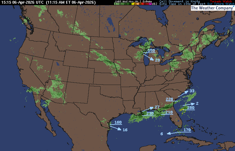
PRECIPITATION TYPE (CLICK TO ACCESS ANIMATION FEATURE) CARIBBEAN RADAR (CLICK IMAGE)
 You may direct any questions by contacting me personally ANYTIME, at: [email protected]
Have a blessed day!
T. F. “STORM” WALSH III
GMCS, USCG (ret)
METEOROLOGIST / HURRICANE SPECIALIST /SEVERE WEATHER SPECIALIST


 English (US) ·
  French (CA) ·