
 3 months ago
114
3 months ago
114
PROTECT YOUR DNA WITH QUANTUM TECHNOLOGY
Orgo-Life the new way to the future Advertising by AdpathwayDisclaimer: This site is not affiliated with the National Hurricane Center, Hurricane Hunters, Storm Prediction Center, or National Weather Service. ALL forecasts herein are the result of my analysis, (to which you will see me at times, insert excerpts from various agencies due to the nature of the importance of the information) and I am solely responsible for the content. As ALWAYS, follow the National Hurricane Center, National Weather Service, and your local Emergency Management officials for emergency decisions. In addition, this is strictly a FORECAST OFFICE. I CANNOT make decisions regarding travel plans, etc. My purpose, is to provide you the information, based solely on information I analyze, and the accuracy of the information at hand of the time of analysis, so you may make informed decisions.
(T. F. “Storm” Walsh)
Thanks to all of you that still follow my forecasts. I truly appreciate each and every one of you!
For those who have donated to my site, your help has been greatly appreciated. If you are not aware, donations to my site help pay for subscriptions to sites I use as well as software updates, which provide all the models and information used in my forecasts. To donate, please click the DONATE button to the right side of the page, or on the graphic of the dog. Any help you provide is immensely appreciated!
DONATIONS NEEDED AND APPRECIATED


I will reiterate, my forecasts are based on the available information at the time of analysis, and are only as accurate as the information analyzed and the solutions provided.
Good day everyone!
The forecast office is closed on Sunday.
The issuance of this synopsis is later, as I wanted to give the models time to all cycle through the 12Z run in order to have the information from the NAM 3km, which will run out to the time of peak intensity regarding forecast indices.
The Storm Prediction Center has a SLIGHT severe weather risk in their DAY 3 severe weather outlook: ACROSS PORTIONS OF THE MIDWEST AND OHIO VALLEY…
…SPC SUMMARY…
Scattered strong to severe thunderstorms are expected late Thursday afternoon and evening across parts of the Midwest and Ohio River Valley.
STORM PREDICTION CENTER (SPC) DAY 3 SEVERE WEATHER OUTLOOK (LINKED)


NADOCAST maps will not be available until the SPC DAY 1 outlook.
The following are the current CSU – MLP and NSSL – ML severe weather guidance forecast maps for DAY3:
CSU – MLP DAY 3 SEVERE WEATHER PROBABILITY MAPS (CLICK FOR LARGER IMAGE)


NSSL – ML DAY 3 SEVERE WEATHER PROBABILITY MAP


DAY 3 PROBABILITY CONVERSION TABLE

SPC DISCUSSION EXCERPT:
Strong low-level forcing along the frontal boundary will likely favor convective bands and upscale growth into the evening hours with a predominant severe/damaging wind threat. However, some deterministic solutions suggest a combination of 40-50 knot deep-layer shear vectors oriented off the frontal boundary over the Midwest, lingering pre-frontal capping, and limited broad-scale ascent through a deep layer may promote semi-discrete convection. While confidence in this scenario is limited at this range, a threat for sustained supercells with a significant hail, and perhaps some tornado, threat could emerge.
Based on a consensus of deterministic and ensemble guidance, the severe risk appears greatest across central IL into IN and western OH where strong QPF and convective environment signals (SCP values of 4-6) are noted. However, some severe risk is expected southwestward along the front into MO and far eastern KS where convection may be more isolated. A damaging wind threat may persist into parts of PA and WV overnight, but waning buoyancy eastward towards the Appalachians limits confidence in the eastern extent of the severe threat.
I will continue to monitor the updates of the SPC outlooks for any changes, and intend to update as possible during the week.
Given that analysis was for indices greater than 24 hours out in the forecast period, the following should not be considered absolute as guidance will most likely change over the next few days.
The NAM 3km model current severe indices and parameters indicate at the moment a MODERATELY to top end MODERATELY unstable atmosphere on Thu.
NAM SBCAPE (SURFACE BASED CONVECTIVE AVAILABLE POTENTIAL ENERGY) FORECAST

NAM DEW POINT FORECAST

This current forecast setup could suggest the main risks to be damaging thunderstorm winds / gusts, significant hail, and probable tornado activity, as indices indicate the tornado threat has increased slightly. 5% – 10% SIGNIFICANT severe hatched areas are now in the SPC outlook map. 0 – 3 km SRH values continue to slowly push toward an isolated strong tornado. Strongest indices appear to be located within the darkest shading in the NSSL ML probability forecast map.
The following were the forecast parameters and indices analyzed this morning. Bear in mind, MAXIMUM indices recorded below are for the time of peak intensity. Some indices meanings are posted below the indices themselves, and the NWS page containing a more extensive explanation can be accessed further on in the synopsis: :
SBCAPE: 750- 2500 j/kg-1
MLCAPE: 500 – 2000 j/kg-1
MUCAPE: 750 – 2500 j/kg-1
SRH 0 -1 km: 100 – 300 m2/s2
SRH 0 -3 km: 250 – 400 m2/s2
SRH EFFECTIVE: 150 – 300 m2/s2
L. I.: -3 to -7
SCP: 4 – 12
STP: 0.0 – 1.0
0 -6 km SHEAR: 50 kts – 60 kts
EFF. SHEAR: 40 kts – 50 kts
MID LEVEL LAPSE RATE: 7.5C – 8.0C
DEWPOINT: 62F – 66F
EHI: 1.8– 2.8
TOTAL TOTALS INDEX: 50 – 51C
K INDEX: 20C to 33C
SWEAT INDEX: 395– 450
THOMPSON INDEX: 23 to 40
CRAVEN – BROOKS INDEX: 20,000 – 40,000
The following are some severe weather parameters and indices explanations:
CAPE

ENERGY HELICITY INDEX

K INDEX

TOTAL TOTALS INDEX

STORM RELATIVE HELICITY

LIFTED INDEX

SWEAT VALUES

THOMPSON INDEX

Craven SigSvr Parameter:
The simple product of 100mb MLCAPE and 0-6km magnitude of the vector difference (m/s; often referred to as “deep layer shear”) accounts for the compensation between instability and shear magnitude. Using a database of about 60,000 soundings, the majority of significant severe events (2+ inch hail, 65+ knot winds, F2+ tornadoes) occur when the product exceeds 20,000 m3/s3.

Again, I will be monitoring the situation over the next few days and will make the appropriate changes as warranted.
The following NWS Watch / Warning map will provide local NWS information for your area. Click the image, then once it refreshes, click on your area of interest to view forecasts, any special weather statements, hazards or advisories for your area.
NWS WATCH / WARNING DISPLAY (LINKED…CLICK MAP, THEN YOUR AREA) NWS DOPPLER RADAR LOOP (LINKED, CLICK RADAR MAP)
 RAP RADAR (CLICK IMAGE THEN GO TO LOOP DURATION AND PICK LENGTH OF LOOP, THEN CLICK RADAR SITE)
 WUNDERGROUND RADAR SUMMARY MAP (CLICK FOR UPDATES)
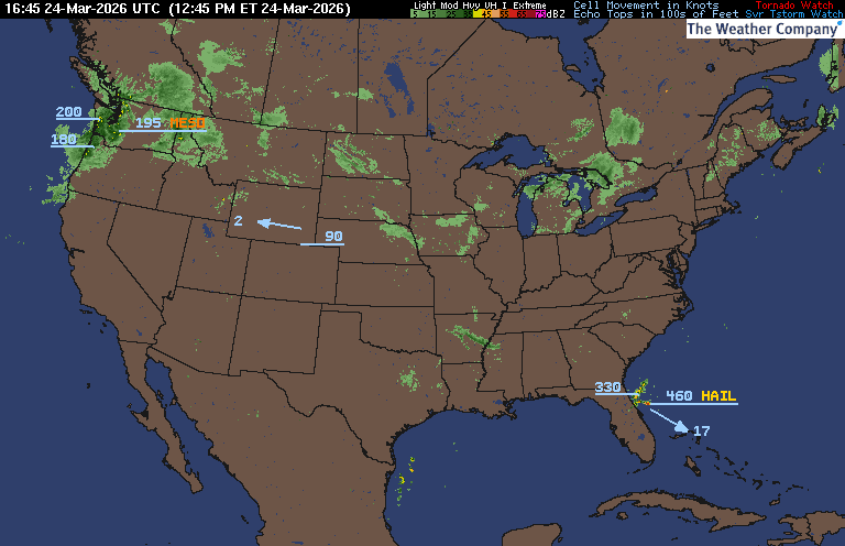
PRECIPITATION TYPE (CLICK TO ACCESS ANIMATION FEATURE) CARIBBEAN RADAR (CLICK IMAGE)
 You may direct any questions by contacting me personally ANYTIME, at: [email protected]
Have a blessed day!
T. F. “STORM” WALSH III
GMCS, USCG (ret)
METEOROLOGIST / HURRICANE SPECIALIST /SEVERE WEATHER SPECIALIST


 English (US) ·
  French (CA) ·