
 7 months ago
289
7 months ago
289
PROTECT YOUR DNA WITH QUANTUM TECHNOLOGY
Orgo-Life the new way to the future Advertising by Adpathway4 December 2025
The term Polar Vortex came into popular use about 12 years ago when Earth’s normally well behaved jet stream went wobbly and forced arctic air into the continental U.S. The high temperature map on 6 January 2014 indicated -20°F in Minnesota!
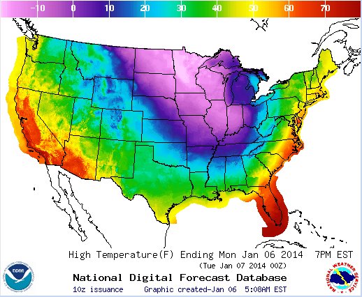 U.S. maximum temperature map for January 6, 2014 (graphic from NOAA)
This week forecasters are talking “Polar Vortex” because the jet stream is wobbling again and we’re seeing the same effect. The slideshow at top is our low temperature series for today through next Tuesday 9 December. Pittsburgh’s highs will be below normal, hovering just above and below freezing.
It was much much colder in January 2014 but the difference this year is that it’s happening sooner, in some places setting temperature records for early December. And it repeats with very cold lows in Pittsburgh on the 4th & 5th, not so bad on 6th & 7th, and back again on 8th & 9th.
video embedded from AccuWeather on YouTube
Considering the repetition, if it’s so cold now will it be even worse six weeks later in mid January? Maybe not.
Sometimes a polar vortex brings unusually hot air. In mid January 2020 it was 70°F in Pittsburgh. Heat doesn’t look likely but we can hope. 😉


 English (US) ·
  French (CA) ·