
 2 months ago
204
2 months ago
204
PROTECT YOUR DNA WITH QUANTUM TECHNOLOGY
Orgo-Life the new way to the future Advertising by AdpathwayDisclaimer: This site is not affiliated with the National Hurricane Center, Hurricane Hunters, Storm Prediction Center, or National Weather Service. ALL forecasts herein are the result of my analysis, (to which you will see me at times, insert excerpts from various agencies due to the nature of the importance of the information) and I am solely responsible for the content. As ALWAYS, follow the National Hurricane Center, National Weather Service, and your local Emergency Management officials for emergency decisions. In addition, this is strictly a FORECAST OFFICE. I CANNOT make decisions regarding travel plans, etc. My purpose, is to provide you the information, based solely on information I analyze, and the accuracy of the information at hand of the time of analysis, so you may make informed decisions.
(T. F. “Storm” Walsh)
For those who have donated to my site, your help has been greatly appreciated. If you are not aware, donations to my site help pay for subscriptions to sites I use as well as software updates, which provide all the models and information used in my forecasts. To donate, please click the DONATE button to the right side of the page, or on the graphic of the dog. Any help you provide is immensely appreciated!
DONATIONS ACCEPTED AND APPRECIATED


I will reiterate, my forecasts are based on the available information at the time of analysis, and are only as accurate as the information analyzed and the solutions provided.
Good evening everyone!
Today marks the start of issuance of Tropical Weather Outlooks from the NHC.
Regarding Tropical Weather Outlook issuance and Tropical Storm / Hurricane forecasts versus Severe Weather forecasts, IF a tropical system becomes a threat to the Caribbean islands, Mexico or any portion of the U.S. during any forecast of severe weather, the tropical system will take precedence. STORM W PRE-SEASON FORECAST
TOTAL NAMED STORMS: 10 – 13
TOTAL HURRICANES : 4 – 6
MAJOR HURRICANES: 1 – 3
AVERAGE HURRICANE SEASON:
TOTAL NAMED STORMS: 14
TOTAL HURRICANES: 7
MAJOR HURRICANES: 3
CSU (Dr. Phil Klotzbach) SEASONAL FORECAST
TOTAL NAMED STORMS: 13
TOTAL HURRICANES: 6
MAJOR HURRICANES: 2
WEATHERBELL (Chief Forecaster Joe Bastardi)
TOTAL NAMED STORMS: 9 – 13
TOTAL HURRICANES: 3 – 5
MAJOR HURRICANES: 1 – 2
The following is the list of storm names for the 2026 Atlantic Hurricane Season:
Arthur Bertha Cristobal Dolly Edouard Fay Gonzalo Hanna Isaias
Josephine Kyle Leah Marco Nana Omar Paulette Rene Sally Teddy Vicky
Wilfred
As we go through the season and storms are named, I will mark them in RED to indicate active, or already named systems.
ATLANTIC GOES 19 SATELLITE LOOPS (IR AND WATER VAPOR)

The NHC indicates tropical cyclone activity is not expected during the next 7 days:
NHC 7 DAY TROPICAL WEATHER OUTLOOK (LINKED)
The ECMWF EPS cyclone formation probability forecast does not indicate any development probabilities during the next 72 – 120 hours:
ECMWF EPS CYCLONE FORMATION PROBABILITY

Two Tropical Waves were detected with one located near 33W and the other near 55W as of the 12Z NHC TAFB surface analysis. I have the wave axis drawn in the following TPW (Total Precipitable Water) image with black lines.
TPW IMAGE (WAVE AXIS’ IN BLACK)
Analysis of global models this afternoon do not indicate any develop during the next 120 hours. I will be using the ECMWF model for graphics given it is considered the more accurate of the global models
ECMWF MSLP ANOMALY FORECAST 120 HOURS
Models also indicate conditions to remain unfavorable for development with dry air, African dust, and wind shear over pretty much of the majority of the Atlantic basin.
ECMWF 500 MB RELATIVE HUMIDITY AND PRECIPITABLE WATER FORECAST 120 HOURS

NASA GEOS AFRICAN DUST FORECAST 
ECMWF WIND SHEAR FORECAST
The MJO (Madden Julian Oscillation) is currently in an unfavorable phase for tropical development. It will however be entering favorable phases by the end of the month to the first week of June. The most favorable phases for development in the Atlantic basin are phase 1, 2, and 3
MJO PHASE SPACE DIAGRAM FORECAST FROM ACCESS-S2 AND ECMWF

I do not expect tropical cyclone formation during the next 5 – 7 days. I will however continue to monitor the tropics for any significant changes to forecast conditions.
NWS WATCH / WARNING DISPLAY (LINKED…CLICK MAP, THEN YOUR AREA)
NWS DOPPLER RADAR LOOP (LINKED, CLICK RADAR MAP)
RAP RADAR (CLICK IMAGE THEN GO TO LOOP DURATION AND PICK LENGTH OF LOOP, THEN CLICK RADAR SITE)
WUNDERGROUND RADAR SUMMARY MAP (CLICK FOR UPDATES)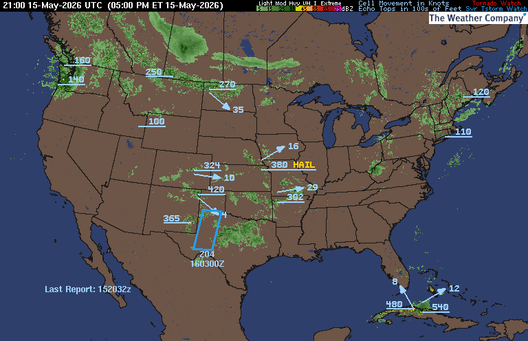
CARIBBEAN RADAR (CLICK IMAGE TO ACCESS ANIMATION)
You may direct any questions by contacting me personally, ANYTIME, at: [email protected]
Have a blessed evening!
T. F. “STORM” WALSH III
GMCS, USCG (ret)
METEOROLOGIST / HURRICANE SPECIALIST /SEVERE WEATHER CoCoRAHS OBSERVER


 English (US) ·
  French (CA) ·