
 6 months ago
116
6 months ago
116
PROTECT YOUR DNA WITH QUANTUM TECHNOLOGY
Orgo-Life the new way to the future Advertising by AdpathwayDisclaimer: This site is not affiliated with the National Hurricane Center, Hurricane Hunters, Storm Prediction Center, or National Weather Service. ALL forecasts herein are the result of my analysis, (to which you will see me at times, insert excerpts from various agencies due to the nature of the importance of the information) and I am solely responsible for the content. As ALWAYS, follow the National Hurricane Center, National Weather Service, and your local Emergency Management officials for emergency decisions. In addition, this is strictly a FORECAST OFFICE. I CANNOT make decisions regarding travel plans, etc. My purpose, is to provide you the information, based solely on information I analyze, and the accuracy of the information at hand of the time of analysis, so you may make informed decisions.
(T. F. “Storm” Walsh)
Thanks to all of you that still follow my forecasts. I truly appreciate each and every one of you!
For those who have donated to my site, your help has been greatly appreciated. If you are not aware, donations to my site help pay for subscriptions to sites I use as well as software updates, which provide all the models and information used in my forecasts. To donate, please click the DONATE button to the right side of the page, or on the graphic of the dog. Any help you provide is immensely appreciated!
DONATIONS NEEDED AND APPRECIATED


I will reiterate, my forecasts are based on the available information at the time of analysis, and are only as accurate as the information analyzed and the solutions provided.
Good day everyone!
The Storm Prediction Center does not indicate any severe weather probabilities, except for portions of CA. on Wed. This is out of my area of responsibility, as I forecast from the central US, eastward. While the SPC does not indicate any other areas for the week, both the CSU – MLP and NSSL ML severe weather guidance forecast is suggesting a possibility for a MARGINAL risk by Fri. I will continue to monitor this as we go through next week.
CSU – MLP / NSSL ML DAY 5 SEVERE WEATHER FORECAST MAPS (LINKED FOR LARGER IMAGES)


I will be using the ECMWF model for the main forecast graphics for winter weather forecasts. Over my years of forecasting, I prefer this model, as numerous articles depict the ECMWF to be the more accurate model as compared to the GFS. Here is an excerpt from an article I found:
The ECMWF model’s resolution is 9km or about 5.5 miles. The GFS has a resolution of 25km or roughly 15.5 miles. This resolution is the distance between two points on a grid that the weather model uses. The smaller the number, the better the resolution/quality of a forecast. The European Center for Medium-Range Weather Forecasts (ECMWF) model is another global numerical weather prediction model that is highly regarded for its accuracy. It employs advanced data assimilation techniques and sophisticated numerical algorithms to simulate atmospheric processes. The ECMWF model provides high-resolution forecasts for various meteorological variables, enabling forecasters to make more precise predictions. According to current weather forecasting standards, the ECMWF model is generally considered the most accurate for predicting snowfall totals, often performing slightly better than American weather models like the GFS.
For forecast temperatures less than 72 hours out in the forecast period, I prefer using the NAM (North American Mesoscale) model. This is what we refer to as a regional model, vice a global model, with its forecast grids within the North American continent. The NAM 3km only goes out to 60 hours, and the NAM 12km goes out to 84 hours.
Should a forecast indicate very cold temperatures, or cold snowy weather:

The following link is from the Animal Welfare Act, and provides guidelines for temperatures regarding your animal:
ANIMAL WELFARE ACT
https://www.aphis.usda.gov/sites/default/files/ac-tech-note-temp-req-dogs.pdf
UNITED STATES SATELLITE LOOP

WPC 15Z SURFACE MAP (LINKED TO SURFACE MAP/RADAR ANIMATION)

The QBO has re-entered the easterly phase according to the recent QBO graph.
CURRENT QBO PHASE

How the QBO influences the polar vortex:
- Easterly phase (QBO-E): This phase is associated with a weaker and more disrupted polar vortex. The weaker vortex is less able to contain arctic air, which can then escape and lead to colder outbreaks in lower latitudes.
- Westerly phase (QBO-W): In contrast, the QBO-W phase is linked to a stronger and more stable polar vortex.The following are links to some of the articles regarding the QBO and SSW
https://en.wikipedia.org/wiki/Quasi-biennial_oscillationhttps://en.wikipedia.org/wiki/Sudden_stratospheric_warming
https://climateimpactcompany.com/quasi-biennial-oscillation-phase-and-sudden-stratospheric-warming-events/https://www.google.com/url?sa=t&source=web&rct=j&opi=89978449&url=https://journals.ametsoc.org/downloadpdf/view/journals/atsc/71/1/jas-d-13-096.1.pdfAlthough the QBO has shifted, the ECMWF stratosphere forecast indicates we should still continue to cycle out of the current SSW phase by the end of the month. I will continue to monitor this, to see if another SSW event enters the forecast.
00Z ECMWF 5 DAY FORECAST 10 MB TEMPERATURE AND PRESSURE ANOMALIES ANIMATION 22 DEC – 27 DEC

LONG RANGE 10 MB TEMPERATURE AND PRESSURE ANOMALIES SHOWING REVERSAL


As the current SSW pattern continues to progress, the current setup may be responsible for setting up a “Rex Block”. This can be seen in the 500 mb and 200 mb charts. You will also note a deep dip in the jetstream in the 200 mb forecast chart, allowing for cold air to come south.
REX BLOCK (CLICK FOR EXPLANATION)

ECMWF NORTHERN HEMISPHERE 500 MB FORECAST MAP 28 DEC

200 MB FORECAST MAP (INDICATES JETSTREAM POSITION) 28 DEC

As the current continued progression of alternating high and low pressure systems across the U.S. continues, along with the “Rex Block” setup, colder temperatures can be expected by the 28th – 29th, with Arctic air affecting the north central states and Great Lakes region, after a brief Christmas “warm up”. Snow is also in the forecast mainly for the NE and Great Lakes region.
00Z 120 HOUR ECMWF MSLP ANIMATION

ECMWF 00Z 120 HOUR SURFACE WINDS FORECAST


ECMWF SIGNIFICANT WAVE HEIGHT FORECAST

ECMWF TEMPERATURE FORECAST FOR DEC. 28 – 29, 2025 ANIMATION


The following are forecast snowfall accumulation totals for the next 5 days, and precipitation totals by type.
ECMWF 120 HOUR FORECAST KUCHERA SNOWFALL TOTALS AND PRECIPITATION TOTALS BY TYPE


The following are minimum temperatures for the succeeding day from the issuance of this synopsis:
MINIMUM AND APPARENT TEMPERATURES DEC. 23, 2025


APPARENT


WUNDERGROUND FROST AND FREEZE FORECAST FOR DEC. 23, 2025

WINTER STORM SEVERITY INDEX DAY 1 – 3 (LINKED FOR INTERACTIVE MAP)

The following NWS Watch / Warning map will provide local NWS information for your area. Click the image, then once it refreshes, click on your area of interest to view forecasts, any special weather statements, hazards or advisories for your area.
NWS WATCH / WARNING DISPLAY (LINKED…CLICK MAP, THEN YOUR AREA)

NWS DOPPLER RADAR LOOP (LINKED, CLICK RADAR MAP)

RAP RADAR (CLICK IMAGE THEN GO TO LOOP DURATION AND PICK LENGTH OF LOOP, THEN CLICK RADAR SITE)
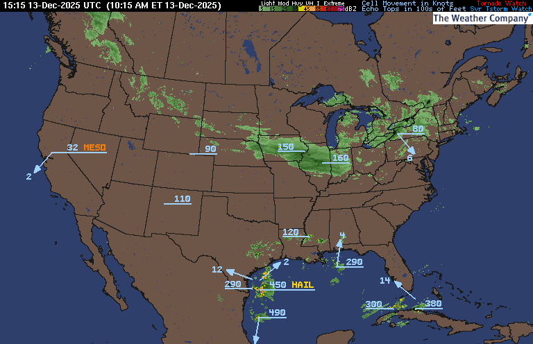
WUNDERGROUND RADAR SUMMARY MAP (CLICK FOR UPDATES)
PRECIPITATION TYPE (CLICK TO ACCESS ANIMATION FEATURE)

CARIBBEAN RADAR (CLICK IMAGE)

You may direct any questions by contacting me personally, ANYTIME, at: [email protected]
Have a blessed day!
T. F. “STORM” WALSH III
GMCS, USCG (ret)
METEOROLOGIST / HURRICANE SPECIALIST /SEVERE WEATHER SPECIALIST


 English (US) ·
  French (CA) ·