
 4 months ago
98
4 months ago
98
PROTECT YOUR DNA WITH QUANTUM TECHNOLOGY
Orgo-Life the new way to the future Advertising by AdpathwayDisclaimer: This site is not affiliated with the National Hurricane Center, Hurricane Hunters, Storm Prediction Center, or National Weather Service. ALL forecasts herein are the result of my analysis, (to which you will see me at times, insert excerpts from various agencies due to the nature of the importance of the information) and I am solely responsible for the content. As ALWAYS, follow the National Hurricane Center, National Weather Service, and your local Emergency Management officials for emergency decisions. In addition, this is strictly a FORECAST OFFICE. I CANNOT make decisions regarding travel plans, etc. My purpose, is to provide you the information, based solely on information I analyze, and the accuracy of the information at hand of the time of analysis, so you may make informed decisions.
(T. F. “Storm” Walsh)
Thanks to all of you that still follow my forecasts. I truly appreciate each and every one of you!
For those who have donated to my site, your help has been greatly appreciated. If you are not aware, donations to my site help pay for subscriptions to sites I use as well as software updates, which provide all the models and information used in my forecasts. To donate, please click the DONATE button to the right side of the page, or on the graphic of the dog. Any help you provide is immensely appreciated!
DONATIONS NEEDED AND APPRECIATED


I will reiterate, my forecasts are based on the available information at the time of analysis, and are only as accurate as the information analyzed and the solutions provided.
Good day everyone!
The Storm Prediction Center does not indicate any severe weather probabilities for the week.
I will be using the ECMWF model for the main forecast graphics for winter weather forecasts. Over my years of forecasting, I prefer this model, as numerous articles depict the ECMWF to be the more accurate model as compared to the GFS. Here is an excerpt from an article I found:
The ECMWF model’s resolution is 9km or about 5.5 miles. The GFS has a resolution of 25km or roughly 15.5 miles. This resolution is the distance between two points on a grid that the weather model uses. The smaller the number, the better the resolution/quality of a forecast. The European Center for Medium-Range Weather Forecasts (ECMWF) model is another global numerical weather prediction model that is highly regarded for its accuracy. It employs advanced data assimilation techniques and sophisticated numerical algorithms to simulate atmospheric processes. The ECMWF model provides high-resolution forecasts for various meteorological variables, enabling forecasters to make more precise predictions. According to current weather forecasting standards, the ECMWF model is generally considered the most accurate for predicting snowfall totals, often performing slightly better than American weather models like the GFS.
For forecast temperatures less than 72 hours out in the forecast period, I prefer using the NAM (North American Mesoscale) model. This is what we refer to as a regional model, vice a global model, with its forecast grids within the North American continent. The NAM 3km only goes out to 60 hours, and the NAM 12km goes out to 84 hours.
Should a forecast indicate very cold temperatures, or cold snowy weather:

The following link is from the Animal Welfare Act, and provides guidelines for temperatures regarding your animal:
ANIMAL WELFARE ACT
https://www.aphis.usda.gov/sites/default/files/ac-tech-note-temp-req-dogs.pdf
UNITED STATES SATELLITE LOOP (LINKED)
 WPC 12Z SURFACE MAP (LINKED TO SURFACE MAP/RADAR ANIMATION)

The QBO graph has not updated since JAN. 21. Since I currently have no type of access to this information, I will be excluding it from the forecasts.
Current analysis of the Stratosphere forecast tends to indicate we will be cycling through another Stratospheric warming event. This is forecast to be centered closer to Canada, just south of the the N. Pole. The 10mb pressure anomaly pattern will be split by day 5 in the forecast period. This may cause somewhat of another disruption in the Polar Vortex, however Arctic air appears to be mainly over Canada, and a small portion of some of the north central states by that time in the period.
00Z ECMWF 10 MB TEMPERATURE AND PRESSURE ANOMALIES FOR 12Z FEB. 23 – 12Z FEB. 28


The following video demonstrates a good example of how an SSW affects the Polar Vortex:
https://youtu.be/mkwbI0t3wBw
The following paper defines a SSW event:
https://www.arl.noaa.gov/documents/JournalPDFs/Butler_et_al_2015_bams-d-13-00173.1.pdf
The current setup is producing a Rex block which is aiding in a strong dip in the mid level wind pattern, as well as in the jetstream over the eastern and SEUS. This again will allow for freezing temperatures to extend all the way into portions of central Florida. By day 5 in the period, the Rex block will transition to more of a blocking ridge pattern over southern Alaska.
OMEGA BLOCK (CLICK FOR EXPLANATION)

ECMWF NORTHERN HEMISPHERE 500 MB FORECAST MAP FOR 12z FEB. 23 AND 12Z FEB. 28


250 MB FORECAST MAP (INDICATES JETSTREAM POSITION) 12Z FEB. 23 AND 12Z FEB. 28


ECMWF SURFACE TEMPERATURE ANIMATION DAY 1 – 5

As a series of winter storms / low pressure systems progress across southern Canada and extreme northern U.S. during this week, more winter precipitation and snow is in the forecast and should mostly affect the NE, New England, Great Lakes, and parts of the north central region of the country. The following you tube video gives a brief explanation of the difference between freezing rain and sleet.
FREEZING RAIN AND SLEET
https://youtu.be/r0J74ex6Iyo
00Z 120 HOUR ECMWF MSLP ANIMATION

ECMWF 00Z 120 HOUR SURFACE WINDS FORECAST


ECMWF SIGNIFICANT WAVE HEIGHT FORECAST

The following are forecast snowfall accumulation totals for the next 5 days, and precipitation totals by type.
ECMWF 5 DAY FORECAST KUCHERA SNOWFALL TOTALS AND PRECIPITATION TOTALS BY TYPE EASTERN U.S.

FREEZING RAIN

SLEET

CENTRAL U.S. 5 DAY SNOWFALL

FREEZING RAIN

SLEET

The following are minimum temperatures for the succeeding day from the issuance of this synopsis:
NAM 3KM MINIMUM AND APPARENT TEMPERATURES FEB. 24, 2026


APPARENT TEMPERATURE


WUNDERGROUND FROST AND FREEZE FORECAST FOR FEB. 24, 2026

(It was noted that the frost / freeze map may not have updated properly, as freeze watches and warnings are in effect for central Florida per the NWS Watch / Warning display map)
WINTER STORM SEVERITY INDEX DAY 1 – 3 (LINKED FOR INTERACTIVE MAP)

The following NWS Watch / Warning map will provide local NWS information for your area. Click the image, then once it refreshes, click on your area of interest to view forecasts, any special weather statements, hazards or advisories for your area.
NWS WATCH / WARNING DISPLAY (LINKED…CLICK MAP, THEN YOUR AREA)

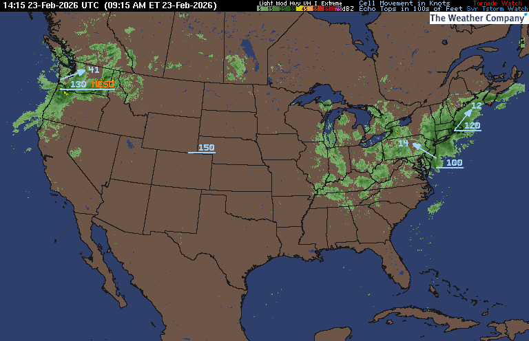
NWS DOPPLER RADAR LOOP (LINKED, CLICK RADAR MAP)

RAP RADAR (CLICK IMAGE THEN GO TO LOOP DURATION AND PICK LENGTH OF LOOP, THEN CLICK RADAR SITE)
WUNDERGROUND RADAR SUMMARY MAP (CLICK FOR UPDATES)
PRECIPITATION TYPE (CLICK TO ACCESS ANIMATION FEATURE)

CARIBBEAN RADAR (CLICK IMAGE)

You may direct any questions by contacting me personally, ANYTIME, at: [email protected]
Have a blessed day!
T. F. “STORM” WALSH III
GMCS, USCG (ret)
METEOROLOGIST / HURRICANE SPECIALIST /SEVERE WEATHER SPECIALIST


 English (US) ·
  French (CA) ·