PROTECT YOUR DNA WITH QUANTUM TECHNOLOGY
Orgo-Life the new way to the future Advertising by AdpathwayCan't even see Jamaica in this image.
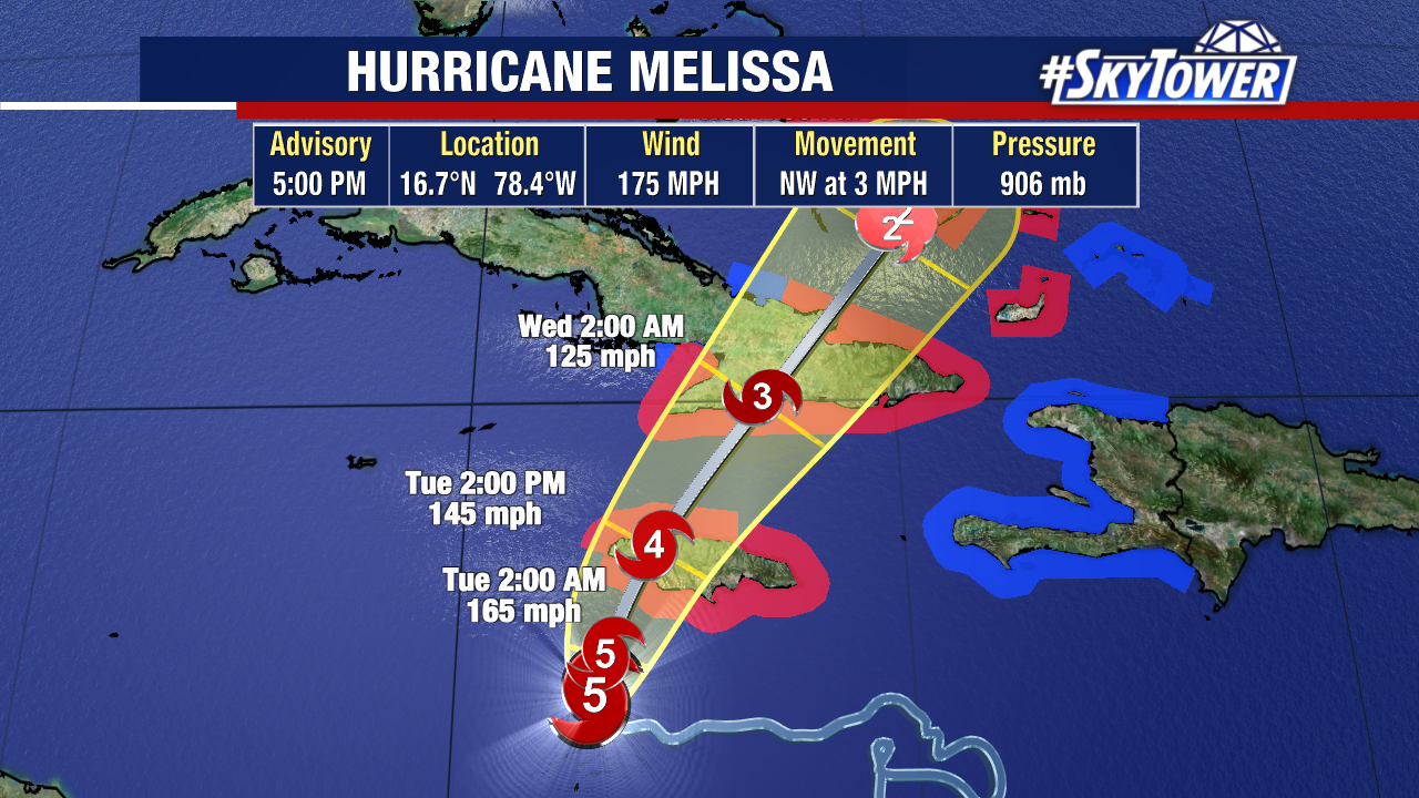
NHC out early with the 5 PM
Note that's forecast movement.
It's forecast to move NW at 3 MPH.
Still 175 MPH winds
906 MB flirting with 800s...
Again short term part of the Cone below.
Longer term track!
Track literally goes off the map.
Bermuda in the crosshairs!
Discussion explains the advisory.
No current changes.
No eye wall replacement cycles yet.
Maintaining strength.....
After Jamaica and it's mountains..
..and Cuba some shear may weaken it.
Moves faster after Cuba towards Bahamas.
You can see the perfection below.
Can't remember one that looked like this..
...like a child tracing colors perfectly
in a circle!
In motion below
This is a current loop....
Went to Dvorak to watch the movement of the eye.
Easier to see in shades or gray, black and white
The red on IR is so distracting.
Looks West to me.
Doesn't look WNW
But NHC gets to make that call.
Years back I used to follow this site religiously, they are incredibly good for Caribbean hurricanes. You get a feel for the Islands, the people. There are reports from various islands.
I'm posting the blog to show you the truth...
...the reality and hopefully you will follow.
I really could not say it better and I'm running out of words to warn people of the dangers. I've said much of this online, on X and in the blog. Here's someone else saying, someone I always enjoyed reading. Enjoy, check them out they are very basic and that's good. With a touch of feel for the islands you won't get on some glitzy site with graphics and links all trying to impress you. Words matter.
I'll update at 8 PM if there is any real change and later at 11 PM. I said I'd keep the blog short after going long this morning. Thanks for reading and please check them out as Jamaica is as Caribbean as it gets!
Besos BobbiStorm
back later with an update. Song at the bottom.
"
Monday, October 27, 2025 10:58AM EDT - Not much more to say Melissa
Good morning for most,
Not so much for Jamaica, Central to Eastern Cuba, Haiti, and the DR from the outflow and tail. Melissa sounds like a delicate, comforting name but in this case, not even close. In fact, if there was a Category 6 hurricane status designation, I believe she could achieve this before the initial landfall at a potential 175 mph into south central Jamaica if the forecast sharp turn to the N then NE is correct. The farther west she goes, she will become the very worst she can be with the right NE quadrant pounding ashore over most of the country although being a highly compact, tightly wound up system, the far eastern side of the island will be spared the worst. Storm surge, while limited by the near shoreline topography, will be catastrophic and deadly while the top level winds over 160 mph will be leveling. Wherever the eye lands, as forecast at the moment, on top of the city of Black River, in St. Elizabeth Parish in SW Jamaica, destruction will be virtually complete.
There are numerous, over 800 shelters, open in Kingston, the Capital, alone. Yet, as of this writing, only 32 have residents in them. From various news reports and postings, most residents want to ride this out for fear of their homes being looted after the storm passes or even during the storm. Sadly, this will potentially be the worst decision of your lives since it might cost you your lives and your possessions that you tried to save/salvage as well. This is not just endemic to Kingston. The closer to the landfall, the manifestation of this reality increases dramatically.
Now, outliers. Being the strongest system in the Atlantic this season, it will be steered by any trough/front that drops down from the CONUS, mainland US. So, it is expected to start turning this evening into tomorrow for it's landfalling encounter with Jamaica. When will that turn occur is anyone's real guess.Will it pass by the west coast of Jamaica before turning? Possibly if the trough/front is a late arriving date. Defying most expectations, a couple outliers show a swing and a miss and Melissa heads towards Central America. Remote possibility, yes. Probably? No. With Mother Nature, you must account for all the possibilities, no matter how remote.
Bottom line. Hurricane Melissa is dangerous, deadly, and potentially/probably catastrophic for all in her path and that includes the Turks/Caicos. Yes, the mountainous terrain of Jamaica and eastern Cuba, if the forecast track manifests itself, knocks her down a few categories after wringing her out of prolific and deadly rainfall, she will still have a rough impact on the T/C. Then Bermuda will probably see the residuals of a declining Melissa.
So much for not much more to say but things needed to be said. Stay safe, vigilant, prepared and please, save your lives by thinking and reacting intelligently. She is nothing to play with. Our prayers are with all.
Dave.
In truth ...heart of the matter is...
...may hearts will be broken from Melissa.
People will die...
(I pray not.....)
...homes will be destroyed.
Roads, bridges too!
Awesome wonderful people.
Grew up with many Jamaican friends...
..Miami is the gateway to the Carib!
They have spirit and heart.
Pray for the best.....
...prepare for the worst!









 English (US) ·
  French (CA) ·