
PROTECT YOUR DNA WITH QUANTUM TECHNOLOGY
Orgo-Life the new way to the future Advertising by Adpathway
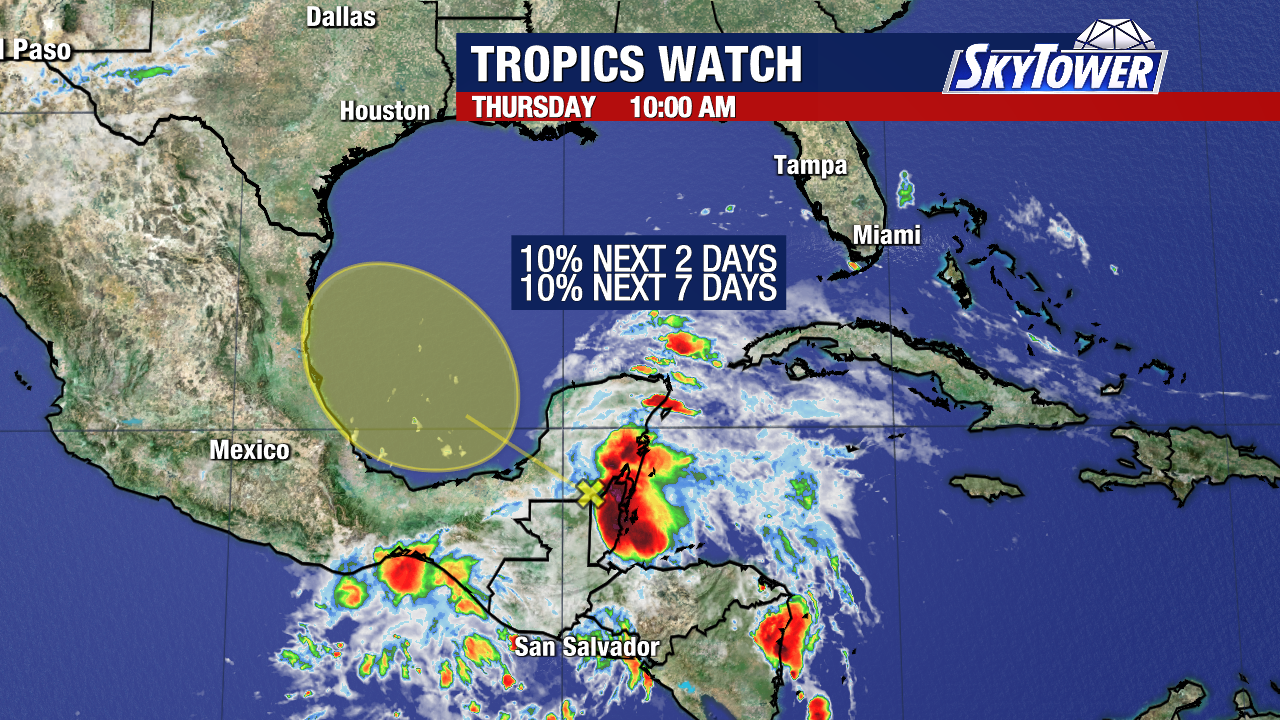
10% still.
The graphic's shape has changed.
.gif)
I could see an Invest coming.. maybe.

I could show the current El Nino graphic ....
...but today this is more important.
Temperatures in the BOC today...
...will, can support development.
Will know soon nuff...
..but will it die out over Mexico
Or
Will the moisture slip away....
...and try to connect to the front.
????

Models from the Spaghetti Model Man!
Mike telling it like it is...
Lots of IFs in the discussion for this interesting graphic. A weak area could try and form before making landfall and then re-emerge over the NW Gulf on TUESDAY and WEDNESDAY and interact with a frontal boundary, but there's lots of IFs still. So the scenario for the front has not evaporated as yesterday's short lived sunshower did in the 100 degree heat, that did I will say drop us down into the low 90s after the raindrops fell briefly before moving on.
I have so many wild thoughts running through my head, but trying to stay on track here this morning. Know tho that the sun woke me up way too early. Even before it rose in the sky as it just showed it's presence near the horizon it felt like a blast of bright light and it was already 80 degrees. This is about as tropical as it gets in the Carolinas, more like back "home" in Miami when we start the day at 80 in June.

Starting off with the reality of CLIMO and what history teaches us about long shots such as Cristina. Rarely does a named storm actually cross the finish line in that part of the world. Everyone was watching to see Cristina do it and yet the closer she got the faster she fell apart. That does not mean the rain did not fall and yet there is a reason few named storms make a landfall. There are always exceptions to the rule, such as Beryl barreling through the Islands when the shear disappeared!

Again this is one region.
They are connected.
Storms near the Yucatan...
..get their energy from down below.
Energy being moisture...
....that feeds them like a gas line.
An electrical current.

Zoom in and you will see why the Bay of Campeche is so favorable this time of year. Be it a forecast crazy, busy bumper crop year or a possibly record breaking El Nino CLIMO tries hard to get its way. There's a reason crappy, messy blobs pull together just before they reach the coast in that region and get a name or designation. So if it became a TD I would not be surprised. It has a ways to go though...
.gif)
So much to look at here and yet there's really not much to say. Wild, huge wave coming off of Africa. Obviously I can say June too soon and it's gonna run into a wall of Saharan Dust. And, yet you can see the lead wave, riding low in the water has hints of vibrant convection. What will this impatient wave look like in two days time I wonder. Really bulked up getting ready to depart Africa.

Note most the storms...
...align vertically here.
For now...
The front is on the move.

ITCZ horizontally.

Some models......hint at...whisper at our area of interest moving West and then the moisture gets jerked fast to to the ENE or NE up into other stronger atmospheric elements. Some take the misture up into areas that could really use the moisture. Where and when do long shots play out is the question. And, the scenario for moisture being slung backwards into the Gulf and beyond has happened before and will again but will it be this June?

Speaking of El Nino that comes on in the summer, gains momentum in the Fall and reaches towards a crescendo as we approach the holidays. El Nino literally referred to the Christ Chld meaning Christmas Time when this feature was made known before the time of modeling and satellite imagery. The ancient sailors knew it was there as their fish were not where they expected them to be and when the fish were not where they were supposed to be they didn't make money and it impacted their own daily life. Now we say EL NINO and try and find some super hyped up label for it such as Godzilla El Nino. The graphic above from the CSU updated forecast released yesterday shows this graphic. The further West the El Nino spreads, the stronger it becomes. This is the graphic to remember when looking at those graphics with the deep reds over the building El Nino speading West.
So stay tuned.
June is not too soon this year for weak, meager development and that is what we usually see in June in the BOC. El Nino years tend to have surprises and storms take strange tracks and yet for the most part they stay weak. One usually busts through to Major status and sometimes it's in the Atlantic at a high latitude and sometimes it's close in to the beaches of fthe Gulf. So stay prepared, stay aware and have an awesome weekend!
Go Canes! (That's a hockey reference....)
Sweet Tropical Dreams,
Bobbistorm
@bobbistorm on X
X mostly weather, elsewhere whatever .....


 English (US) ·
  French (CA) ·