
 14 hours ago
1
14 hours ago
1
PROTECT YOUR DNA WITH QUANTUM TECHNOLOGY
Orgo-Life the new way to the future Advertising by AdpathwayDisclaimer: This site is not affiliated with the National Hurricane Center, Hurricane Hunters, Storm Prediction Center, or National Weather Service. ALL forecasts herein are the result of my analysis, (to which you will see me at times, insert excerpts from various agencies due to the nature of the importance of the information) and I am solely responsible for the content. As ALWAYS, follow the National Hurricane Center, National Weather Service, and your local Emergency Management officials for emergency decisions. In addition, this is strictly a FORECAST OFFICE. I CANNOT make decisions regarding travel plans, etc. My purpose, is to provide you the information, based solely on information I analyze, and the accuracy of the information at hand of the time of analysis, so you may make informed decisions.
(T. F. “Storm” Walsh)
For those who have donated to my site, your help has been greatly appreciated. If you are not aware, donations to my site help pay for subscriptions to sites I use as well as software updates, which provide all the models and information used in my forecasts. To donate, please click the DONATE button to the right side of the page, or on the graphic of the dog. Any help you provide is immensely appreciated!
DONATIONS ACCEPTED AND APPRECIATED


I will reiterate, my forecasts are based on the available information at the time of analysis, and are only as accurate as the information analyzed and the solutions provided.
Good day everyone!
The following changes are being made. The forecast center is still closed on Sunday, and will be closed on Saturday as well (unless there is a threat from a tropical system). Please refer to the Storm Prediction Center for severe weather information.
SPC LINK
https://www.spc.noaa.gov/
Regarding the issuance of Tropical Weather Outlooks or Tropical Storm / Hurricane forecasts versus Severe Weather forecasts, IF Cyclone Formation Probability models become consistent in probability indicating possible development, or a probability is shown in the NHC GTWO (Graphical Tropical Weather Outlook) or a tropical system becomes a threat to the Caribbean islands, Mexico or any portion of the U.S. or becomes a constant entity in the Atlantic, Caribbean, or Gulf during any forecast of severe weather, the tropical weather forecast will take precedence. These may be lengthy, however I want to always give a full perspective on the tropics.
The SPC indicates an ENHANCED risk for severe weather tomorrow. Please refer to the link above for severe weather updates, or click on the graphic for access:
DAY 2 SEVERE WEATHER OUTLOOK
STORM W SEASONAL FORECAST
TOTAL NAMED STORMS: 10 – 13
TOTAL HURRICANES : 4 – 6
MAJOR HURRICANES: 1 – 3
AVERAGE HURRICANE SEASON:
TOTAL NAMED STORMS: 14
TOTAL HURRICANES: 7
MAJOR HURRICANES: 3
CSU (Dr. Phil Klotzbach) SEASONAL FORECAST
TOTAL NAMED STORMS: 11
TOTAL HURRICANES: 5
MAJOR HURRICANES: 2
WEATHERBELL (Chief Forecaster Joe Bastardi)
TOTAL NAMED STORMS: 9 – 13
TOTAL HURRICANES: 3 – 5
MAJOR HURRICANES: 1 – 2
2026 SEASON TOTALS
TOTAL NAMED STORMS: 0
TOTAL HURRICANES: 0
MAJOR HURRICANES: 0
The following is the list of storm names for the 2026 Atlantic Hurricane Season:
Arthur Bertha Cristobal Dolly Edouard Fay Gonzalo Hanna Isaias
Josephine Kyle Leah Marco Nana Omar Paulette Rene Sally Teddy Vicky
Wilfred
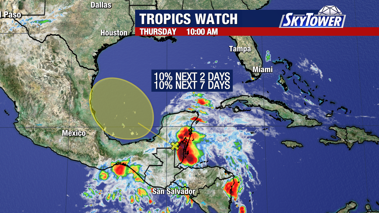
Analysis of GOES satellite loop imagery indicates a weak area of low pressure in the BOC. Thunderstorms this afternoon have become just a little more concentrated around the center of the broad low.
GOES 19 ATLANTIC IR SATELLITE LOOP (LINKED)
YUCATAN SATELLITE LOOP (LINKED)

Based on the NHC 12Z surface analysis, Tropical Waves were located near 29W, 47W, 58W, 69W and 76W Longitude as shown in the 12Z TPW (Total Precipitable Water) image.
CIMSS 12Z TPW
NHC 7 DAY GTWO (LINKED TO OUTLOOK)
The NHC still has a LOW (20%) probability of Tropical Cyclone formation during the next 7 days.
The ECMWF Cyclone Formation Probability forecast is now indicating 70% probability for development between 24 – 72 hours out from the 12Z run.
ECMWF EPS CYCLONE FORMATION PROBABILITY 
Analysis of the global models indicates the low pressure could attain a 1008 mb pressure during 24 – 36 hours. Based on current and forecast low level steering, and information contained in the NHC Outlook, the low could cross into Mexico, possibility just south of the Texas border, by later on Sat. or early Sun. Remnant moisture could bring increased precipitation chances to extreme southern Texas. Currently, the NWS office in Brownsville, TX. has not issued any advisories or statements. However the office does mention rain chances increase this weekend and early next week, as well as adverse marine conditions over the Gulf waters.
Models indicate at the moment that during the next 24 (out to approx. 36 hours in the period), wind shear will continue to decrease, but during the next few hours, upper divergence will become much less favorable. Surface to mid level moisture will remain very favorable based on analysis of PWAT values and 700 mb relative humidity values. The bottom line is, this has approx. 24 hours to possibly intensify before conditions become unfavorable. Based on my analysis, and if what I have seen pans out, the best chance to organize and MAYBE? begin to try to become a depression will be just prior to this coming ashore, which the models show at the 36 hour mark in the period, with wind shear reducing to a favorable level with a radial shear pattern developing, and an upper level anticyclone developing at 200 mb allowing for very good upper level divergence, over the center of the low. So, we have a very short period to see what actually pans out. This will all depend on how soon it actually crosses into Mexico.
Based on my analysis of current and forecast steering layers, this should cross into Mexico, however not very far, by Sun. Thereafter, per the NHC outlook, and shown in the development probability circle, this COULD merge with the approaching frontal boundary, and could turn back to the NNE and re-enter the Gulf, possibly increasing precipitation chances for the central Texas coast and portions of the Louisiana coast.
ECMWF MSLP ANOMALIES FORECAST (9 – 48 HOURS)
ECMWF WIND SHEAR FORECAST, 200 MB STREAMLINE, 700 MB RELATIVE HUMIDITY, AND PRECIPITABLE WATER FORECAST 


CURRENT AND FORECAST STEERING LAYERS FORECAST

NWS WATCH / WARNING DISPLAY (LINKED…CLICK MAP, THEN YOUR AREA)
NWS DOPPLER RADAR LOOP (LINKED, CLICK RADAR MAP)
RAP RADAR (CLICK IMAGE THEN GO TO LOOP DURATION AND PICK LENGTH OF LOOP, THEN CLICK RADAR SITE)
WUNDERGROUND RADAR SUMMARY MAP (CLICK FOR UPDATES)
PRECIPITATION TYPE (CLICK TO ACCESS ANIMATION FEATURE)
CARIBBEAN RADAR (CLICK IMAGE TO ACCESS ANIMATION)
I will continue to monitor the tropics for any significant changes
I do not expect tropical storm formation during the next 5 – 7 days.
Have a blessed evening!


 English (US) ·
  French (CA) ·