

PROTECT YOUR DNA WITH QUANTUM TECHNOLOGY
Orgo-Life the new way to the future Advertising by Adpathway
Guess what popped out just after....
...they sent out the 11 PM

1st Selfie below!!

in motion

New Cone and Rainfall graphics.
Note how far to the East of the Cone...
...the dangerous rain, possible flood concerns.

That said....
will update in the morning.
Plan to be online...
watching the eye.

Keep reading.... was written recently
before the updated 11 PM I added at top.
10 PM

Intensiying.
Cone below.

Close up dangers.

Dangers outside the "Cone"
Rain + Terrain = Pain.
Flash FLooding Concerns.

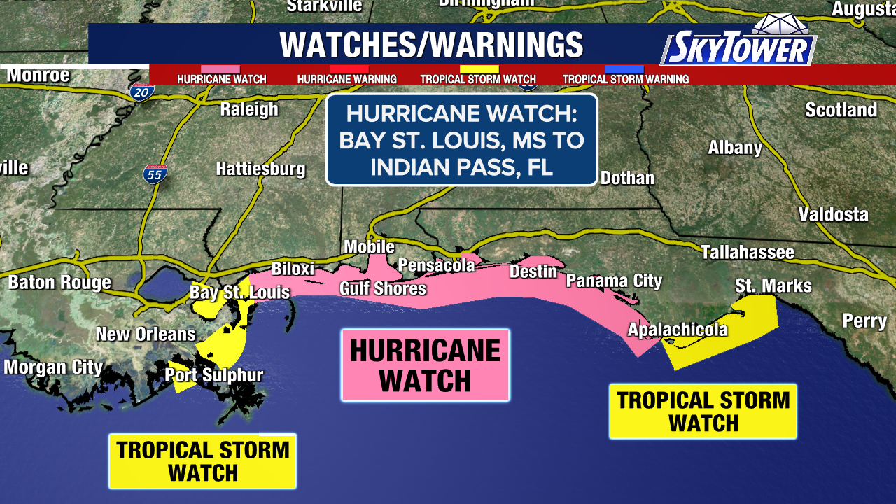
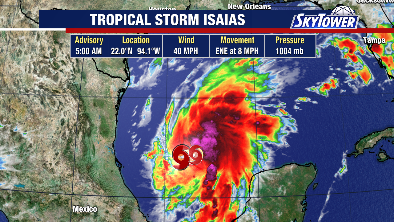
I've been busy all day with appointments that could not be changed, so trying to play catch up here tonight. Rather than go long on models, I'm going to discuss what I'm most concerned about and that is while landfall is important so is weather far from landfall. And depending on what category Hurricane Isaias is at landfall the dangers could be immense, more than most realize. But the "Cone" only forecasts where the "eye" will go and not the dangers inherent in any nearby landfalling Hurricane. Currently Isaias is a strong Tropical Storm. It's hard to look at it down in the Gulf as a tropical storm and think beyond that for some people. And, more so many people focus on the "Cone" and ignore the dangers outside the Cone.
Doesn't scream danger. And yet there are dangers.
What it is forecast to look like in 24 hours is a hurricane, and possibly a strong hurricane. Category 1 or 2, and we tell people to prepare for one category higher always so keep that in mind and do that math tomorrow night.
.gif)
October Hurricanes (and tropical storms) are often mishaped, assymetrical and can at times look blobby. They lean to the right as the system that will pick them up and pull them to the North, the North East towards landfall makes them look this way. The atmospheric dynamics create the shape of the Hurricane. For those of you who have lived along the Florida Panhandle you know this drill, for newbies it's difficult to comprehend. Things can change fast in the Gulf, close in and when a hurricane begins to smell the mucky shores near the coves along the coast from Mobile, Alabama east along the Florida Panhandle and even down towards the Big Bend. A shallow shelf, marshy land... low country and the very shape of the coastline itself sometimes helps nudge a system stronger just before landfall and surge can be high even for a weak storm. And, sometimes they peak out before landfall and deceptively seem weaker than expected and other times they explode just before landfall.
The one thing that is a constant is the storm surge, the moisture that has been caught up in a system and traveled the Gulf towards landfall and that power is strong and destructive. We tend to focus on wind speed with hurricanes. A hurricane is a hurricane when it winds reach 74 MPH. We don't say "when the storm surge is 6 feet high" or "when it will cause flash flooding that can wipe out..." it's all about the wind when we talk designation.
And, yet the real danger is usually the storm surge and the heavy rains and possible tornadoes and flooding in places in places inland where the terrain rises and rain water can run down hill fast and furious. It's all one long run on sentence if you have ever been in a Hurricne in this neck of the woods.
Know your dangers.
The coastline dangers are different from the inland dangers. River Flooding is deceptive and happens fast. And, regarding rain this storm will be RIGHT SIDE HEAVY.... most of the weather will be on the RIGHT SIDE ... to the East far from the Cone.

5 Day Rainfall Totals.
Red & Purple pretty but not good.

Compare the track to the rainfall graphic.
Note how much dangerous weather...
...is far outside the Cone.
Way East of the Cone.
This concerns me.
This worries me.
When Helene hit in W NC
People insisted there was little warnings.
Those who obsessively follow the NHC
... packed up the truck and left fast.
Most did not :(
Many died.
Towns torn apart.
Bridges broken.
Lives destroyed.
Augusta was ripped apart.
Areas in South Carolina...
..suffered heavy damages
far from the eye making landfall.
I worry on North Georgia.
They have had flooding up in the mts lately.
Many town in the foothills...
....of the Appalachians.
I will update after 11 PM
I'll be here tomorrow.
But I do think the storm will pull...
...to the right.
Lean right.
Dry backside.
Wet foreward side.
The East Side.
NE of landfall.
The cone may remain....
...but the dangerous weather...
...will race NE NNE and
eventually East.

That's a whole lot of moisture.
Follow the cookie crumbs.
Wet cookie crumbs.
And I have not even mentioned...
NJ and NY
places way to the North...
that could get torrential rain.
Thanks for your patience.
Follow local weather experts.
Old timers. NWS
Local On Air Experts.
NHC is tracking the center.
The eye ...when it appears.
Besos BobbiStorm
@bobbistorm on X
Hope this publishes correctly.
New laptop. New issues :)
We have not bonded yet...













 English (US) ·
  French (CA) ·