
PROTECT YOUR DNA WITH QUANTUM TECHNOLOGY
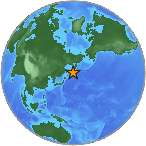
Orgo-Life the new way to the future Advertising by Adpathway A light earthquake magnitude 4.2 (ml/mb) has struck on Wednesday, 33 kilometers (21 miles) from Lamitan in Philippines. The temblor was reported at 21:32:01 / 9:32 pm (local time epicenter). All ids that are associated to the event: us7000qwc7. Unique identifier: us7000qwc7. Exact time and date of event in UTC/GMT: 20/08/25 / 2025-08-20 21:32:01 / August 20, 2025 @ 9:32 pm. Exact location of earthquake, 125.9874° East, 5.9983° North, depth 152.424 km. A tsunami warning has not been issued (Does not indicate if a tsunami actually did or will exist). The earthquake occurred at a depth of 152.424 km (95 miles) below the earth’s surface.
Epicenter of the earthquake was 91 km (57 miles) from General Santos (c. 679 600 pop), 84 km (52 miles) from Maluñgun (c. 52 200 pop), 78 km (48 miles) from Alabel (c. 43 300 pop), 62 km (39 miles) from Malita (c. 41 100 pop), 89 km (55 miles) from Glan (c. 24 300 pop), 77 km (48 miles) from Malapatan (c. 19 400 pop). Closest city/cities/towns to epicentrum/hypocenter was Malalag, Batobato, Conel (min 5000 pop). Country/countries that might be effected, Philippines (c. 99 900 000 pop).
In the past 24 hours, there have been two, in the last 10 days five, in the past 30 days nine and in the last 365 days eighty-six earthquakes of magnitude 3.0 or greater that have been detected nearby. There are an estimated 13,000 light earthquakes in the world each year. Earthquakes 4.0 to 5.0 are often felt, but only causes minor damage.
Did you feel anything?
What was your situation during the earthquake? Leave a comment or report about damage, shaking and activity at your home, city and country. This information comes from the USGS Earthquake Notification Service. Read more about the earthquake, Seismometer information, Date-Time, Location, Distances, Parameters and details about this quake, recorded: 33 km ESE of Lamitan, Philippines.
Copyright © 2025 earthquakenewstoday.com All rights reserved.


 English (US) ·
  French (CA) ·