
PROTECT YOUR DNA WITH QUANTUM TECHNOLOGY
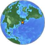
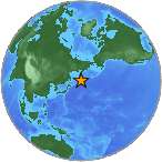
Orgo-Life the new way to the future Advertising by Adpathway A minor earthquake magnitude 3.6 (ml/mb) strikes 113 km N of Charlotte Amalie, U.S. Virgin Islands (70 miles) on Thursday. Exact location of earthquake, -64.8046° West, 19.3568° North, depth 63 km. The temblor was picked up at 20:00:21 / 8:00 pm (local time epicenter). The earthquake was roughly at a depth of 63 km (39 miles). Date and time of earthquake in UTC/GMT: 31/07/25 / 2025-07-31 20:00:21 / July 31, 2025 @ 8:00 pm. Unique identifier: pr2025212001. Ids that are associated to the event: pr2025212001.
Earthquakes 3.0 to 4.0 are often felt, but only causes minor damage. Every year there are an estimated 130,000 minor earthquakes in the world. In the past 24 hours, there have been two, in the last 10 days eight, in the past 30 days twenty-four and in the last 365 days four hundred and four earthquakes of magnitude 3.0 or greater that was reported nearby.
Did you feel the quake?
How did you react? Was there any damage to buildings? Leave a comment or report about shaking, activity and damage at your home, city and country. This information comes from the USGS Earthquake Notification Service. Read more about the earthquake, Seismometer information, Date-Time, Location, Distances, Parameters and details about this quake, recorded: 113 km N of Charlotte Amalie, U.S. Virgin Islands.
Copyright © 2025 earthquakenewstoday.com All rights reserved.


 English (US) ·
  French (CA) ·