
PROTECT YOUR DNA WITH QUANTUM TECHNOLOGY
Orgo-Life the new way to the future Advertising by Adpathway
We recently published a post on the Zuidwal volcano, found buried in the Netherlands and becoming a google sensation – google is still working on removing all the made-up images. But in spite of google, there is a real story behind this volcano. It is the story of the North Sea, the sea that could have become an ocean but remained an ugly duckling. This is the story of that grimme ælling.
Life on the coast
Living near the sea can be good. First and foremost, the sea provides a food supply in the form of fish and shellfish which is available throughout the year. The open water provides fast transport links – ideal for trade but also for raids and invasions. The land is often fertile, especially if there is also a river – and rivers tend to be at their best near the sea. People would flock to the coast. The indomitable village of Asterix is depicted as being at the coast. Nowadays, a staggering 10% of the world’s population lives within 5 kilometres of the coast, crammed together on 2% of the inhabitable land.
But there are also disadvantages. Storms can make the sea a dangerous place, and boat journeys were best avoided in winter. Living too close to sea level also meant being affected by tides, and spring tides could inundate the best land. People put up elevations or mound in the landscape, for their own houses but especially to give their cattle a place of safety. On occasion, floods would overcome the defences, destroying life and livelihoods. And sometimes, the very coastline could change.
We need the sea – but the sea doesn’t need us.
Living with water
The eight nations that border the North Sea have close connections. These were not always friendly ones. England in particular was seen as a tempting target: the poor Brits suffered raids but also successful invasions across the sea from the Romans, the Anglo-Saxons, the Vikings, the Normans, the Dutch, and in return almost never successfully invaded the other way. (There was in fact a successful invasion of Brittany by people from Cornwall, somewhere around the 6th century.)
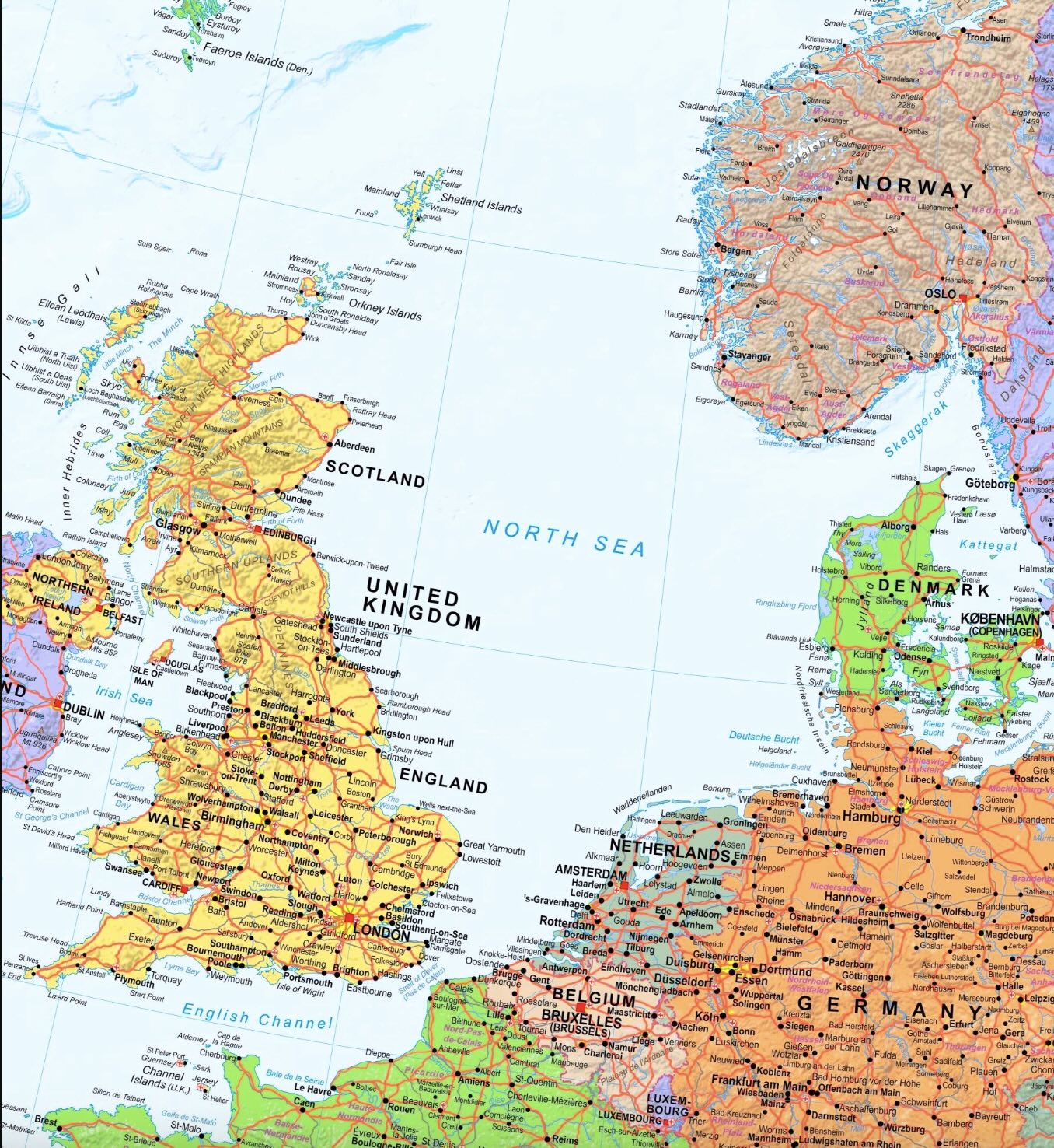
One may wonder why it is called the North Sea. Blame the Dutch for this! The Romans called it, more sensibly, the Oceanus Germanicus (no sea to them!), and England originally adopted this name. The Danes called it the West Sea. But in the Middle Ages, the Dutch had two seas to content with: the big one off the coast, and an in-land sea that had developed and was threatening to swallow much of the country. The in-land one was called the South Sea (‘Zuiderzee’) and the big one became the North Sea.
During Roman times, the Dutch coast line was about where it is nowadays. But the land wasn’t. Rivers fed an inland lake area surrounded by swamps. The coast was protected by sand dunes, formed by sand that came in from the sea. Short rivers connected the lake region to the sea. The river ‘IJ’, the short river on which Amsterdam developed, was one of these. But over time, storm floods attacked the coast. In 1170, the All Saints’ flood created a connection between the lake and the sea, and thus turned the lake into the salty Zuiderzee. Some of the floods became legendary. One of the oldest recorded floods was in December 1287. The floods came early in the morning, before the cocks crowed. Towns near the sea were destroyed and in the north of the Netherlands, reportedly some 50,000 people died. (We should take this number with some caution.) Monks survived better, because they got up for morning prayers well before the chickens, and had time to see the danger coming. The islands of the coast were badly hit. Griend, an island near the mouth of the river Vlie, was much reduced in size and eventually became uninhabitable. In England, Yarmouth was badly damaged.
There was a famous storm flood in 1362, accompanying a hurricane which in England reportedly pulled trees with their roots out of the ground and flattened the church towers of Bury-St-Edmunds and Norwich. The storm became known as the Great Mandrenke (‘men drown’); the flood is called the St Marcellus flood. The flood reportedly destroyed the prosperous German town of Rungholt and killed 3,000 people there. But there are some doubts about this event. Only reports written much later mention the flood – contemporary reports do not. This may be a case where later stories combined different events occuring over decades as a single one. The 1362 St Marcellus flood may have been a mis-remembrance, a fault of history. But if not this flood, then Rungholt was lost in another flood But there were many other devastating floods, which especially during the 13th century altered the Dutch coast line and created both the Zuiderzee and the Waddenzee. The Belgium town of Oostende at that time was on the island of Testerep (at the east end, as the name indicates). But this island was destroyed in the storm of 1394, and Ostende was lost. The town was rebuild on the coast, but kept its name – a phantom of the past. During the Middle Ages, some 250 towns were lost to the sea along the eastern North Sea coast. The most recent storm flood was in 1953 when 2400 people died along the North Sea coasts. And as sea level rises, it will happen again.
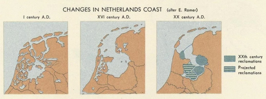
The problem of the Zuiderzee was finally overcome a century ago when a dike turned it back into a lake. Much of it was subsequently turned into polders. (The memory is still recognizable in names such ‘Schiphol’, now an airport in a polder but once a graveyard of sunken ships.) One could imagine that the Dutch would have loved to take the same approach to the entire North Sea and get rid of it. For such a seafaring nation, there is a surprising amount of animosity towards the sea. As one Dutch writer phrased it, the Dutch were shaped by the sea and became it’s opposite.
And I have loved thee, Ocean! and my joy
Of youthful sports was on thy breast to be
Borne like thy bubbles, onward: from a boy
I wantoned with thy breakers—they to me
Were a delight; and if the freshening sea
Made them a terror—’twas a pleasing fear,
For I was as it were a child of thee,
And trusted to thy billows far and near,
And laid my hand upon thy mane—as I do here.
(Lord Byron, Childe Harold’s pilgrimage)
Doggerland
The North Sea wasn’t always a sea. Fishermen would bring back rather non-fishy finds from their nets, such as mammoth tusks and human stone tools, evidence that once this had been dry land.
Much of the North Sea is quite shallow, especially so south of a line that runs from the northern tip of Denmark to Scarborough in England. Along this line lies the Dogger Bank, a sand bank which nowadays is 20-30 meters below sea. (‘Dogger’ was a name for the old trawlers that trawled here for cod.)
During the ice age, sea levels were 100 meter lower and the North Sea was dry land. The modern name for the dry North Sea is Doggerland. It was the size of France, forested and possibly densely (for the time) populated. But the ice melted and the sea level rose, and more and more of the region became submerged. Eventually only the Dogger Bank remained as an island surrounded by the rising sea. A large tsunami around 6150 BCE destroyed most of the island. A part survived for a few more centuries before it too succumbed to the sea and Doggerland became a spectre, a flying Dutchmen of the north.
What happened to the people who lived on the Dogger Bank? We don’t really know. Some may have migrated; many may have died. One wonders whether they ever discussed climate change. Did they notice the sea change, imperceptible over years but destructive over centuries? Did they see their lands diminish? Did they too have arguments around the campfires on whether the danger was real or imagined? Did they sing a song about ‘Dogger Bank ruling the waves’ until they believed it?
The sea is a hungry dog (James Reeves)

Although much of the North Sea is shallow, it does contain two deeper trenches. One is the Norwegian trench, which follows the western coast of Norway, and the second one is the Skagerrak, southeast of Norway. These were below sea level even during the ice ages. In spite of the double name, the two trenches form a single structure. It is not tectonic in origin – no subduction here! (Nor could there be any, in the continental crust of the North Sea.) It is the erosion gulley of an ice glacier which flowed out of the Baltic around Norway into the Atlantic Ocean, and scraped the bedrock to a maximum depth of 700 meter. That was some glacier!
Other than this glacial subsea valley, the North Sea becomes a bit deeper towards the north. Most of the coasts are also low-lying. The main exception is in the north, in the mountains and fjords of Norway create a steep edge to the sea.
Caledonia
The Caledonian Mountains once were a continuous range. They are now divided over Scandinavia, Scotland, Western Ireland, Northeast Greenland and the eastern US, separated by the North Sea and the Atlantic Ocean. Clearly, the sea and ocean are younger than the land. When living on the coast, it seems that the land is temporary and the sea is everlasting. But this isn’t quite true. Continents live forever – oceans die. But there is change and there is resurrection. Continents break up, drift apart, reconnect and join other continents in an everlasting dance of the plates. And extinct oceans can be reborn.
So it happened here. Once, there were the ancient continent of Laurentia in the west and Baltica in the east, separated by the Iapetus ocean. The Caledonian Mountains trace the line where these continents collided and where the Iapetus ocean disappeared. But eventually, the continent that formed from the merger of Laurentia and Baltica broke apart again, in the process forming North America and Europe. In between, the Atlantic Ocean formed – along a line that was almost, but not quite, that of the Caledonian Mountains. Now, one part of the range follows the west coast of northern Europe, whilst the other part lies on the far side, on the east coast of Greenland and in the eastern US.

Supercontinents
There were times when all main continents were joined together. The first supercontinent that we are fairly confident existed is Rodinia, around 1 billion years ago. It broke up into 6 parts. The largest one was Gondwana, consisting of most of the current southern hemisphere plus India. The next largest was Laurentia, in effect modern North America, Greenland and the north of Great Britain. Baltica was (you guessed it) Northern Europe. The others are not part of today’s story: Siberia, Kazakhstania and China. Of course Rodinia itself had formed by assembly; the suture zones where those parts merged are still visible in unexpected and often disconnected places around the world. You can find them in Central Park in New York. The oceans that formed from the break-up of Rodinia include the Iapetus Ocean, surrounding Laurentia.
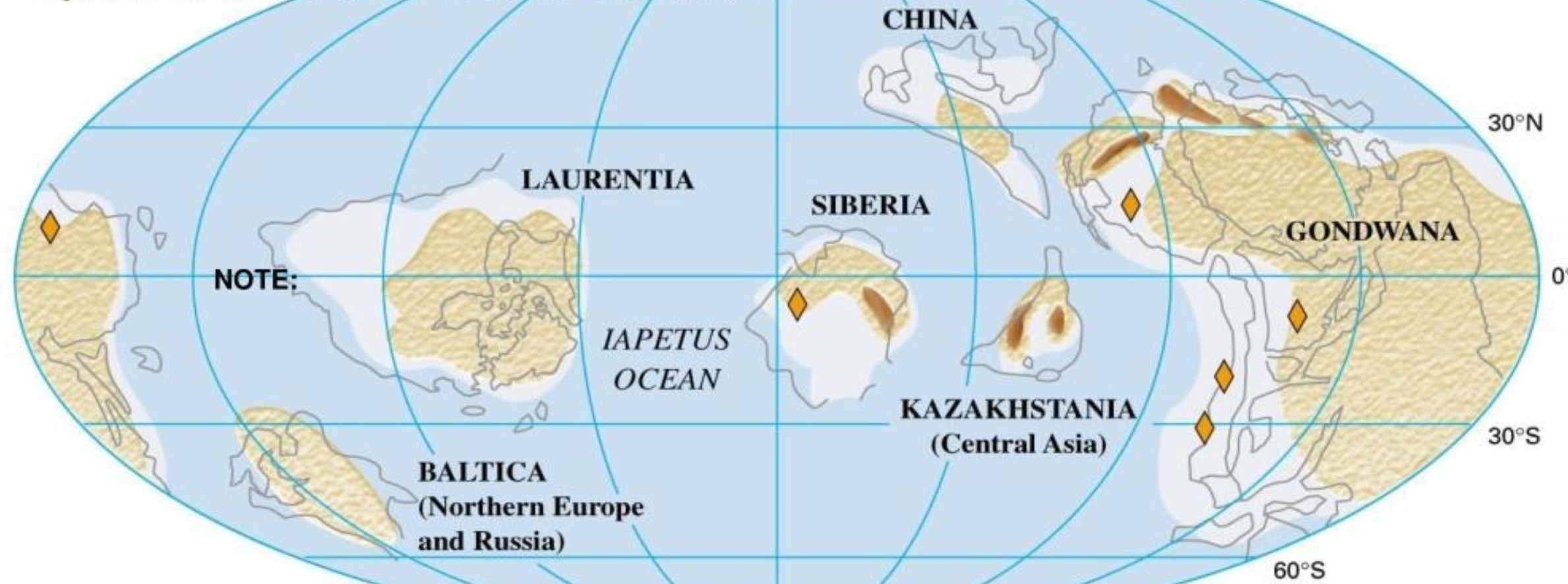
The world after the break-up of Rodinia. This is during the late Cambrian, some 500 million years ago. Be aware that the latitudes are much better known than the longitudes!
At the time, the continents were close to the equator. But Gondwana was on the move and headed south, eventually to become a polar land mass.
After a long time, the Iapetus ocean began to shrink again and Laurentia and Baltica moved closer. But they were being photo-bombed. A continental fragment had rifted off from Gondwana and was rafting across the ocean to join Laurentia and Baltica, closing that ocean in the process. The new ocean behind this fragment became known as the Rheic Ocean. The fragment was Avalonia, and it carried, amongst others, the southern parts of Great Britain, parts of western Europe, most of Newfoundland, and Nova Scotia on the Atlantic coast of Canada. Parts of New England are also from Avalonia. Avalonia docked around 450 million years ago.
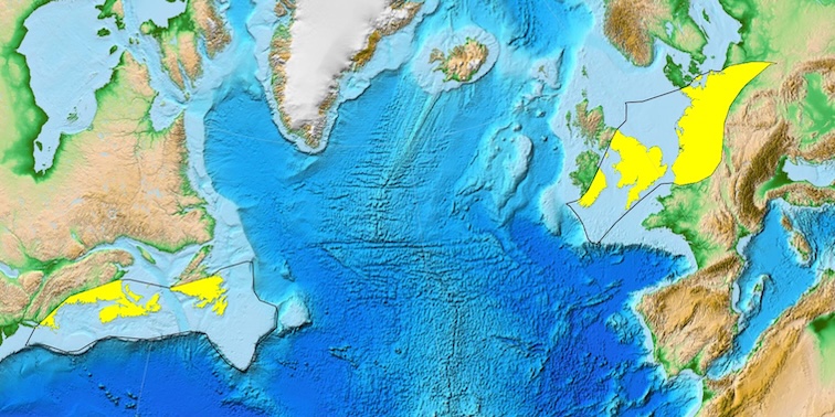
Yellow shows the modern remains of Avalonia. Source: wikipedia
Since Avalonia collided with both Baltica and Laurentia, those two continents must already have been close together. There were not one but three continental collisions in close proximity: Laurentia with Baltica, Avalonia with Baltica and Avalonia with Laurentia. This would form the new continent of Laurasia, around 400 million years ago. In fact, Avalonia was itself not a single entity, but joined Baltica as two separate mini-continents, Avalonia proper and Armorica. This also happened in Laurentia where several other mini-continents joined as part of the same general migration across the ocean. Florida came across as one such block.
The order of the collisions is complex. Basically, East Avalonia joined Baltica 450 million years ago, West Avalonia joined Laurentia some 30 million years later, Laurentia and Baltica joined at around the same time, and Armorica came along around 360 million years ago. There is quite a lot of give or take on the dates: these were not instantaneous events! For instance, the joining of Baltica and Laurentia was scissor-like, starting in the south, and the closing of the scissor took its time.
After all this upheaval the plates were not resting on their laurels. In the east, Kazakhstania would join, forming the Ural mountains, later followed by Siberia. And in the south, Gondwana was waiting. With the closure of the Rheic ocean 300 million years ago, the new supercontinent of Pangea was complete, littered with mountain ranges from all those collisions.
Appalachians

A good example of the complexity is seen in the American Appalachian mountains. These mountains are a combination of several ranges. The oldest range is on the western side and it predates Pangea by a lot. It is the remains of a collision between proto-Laurentia and Amazonia, during the formation of Rodinia. Rodinia later broke up just to the east of this range. When Avalonia joined, it formed another mountain range, east of the older (and by now eroded) one. And finally, the merger with Gondwana formed the biggest range, again just the east. The Appalachians are three-in-one – or even four-in-one, when counting the collision with Baltica wich contributed to the northern ranges of the Appalachian mountains.
Europe
In Europe, the Avalonia collision was a fairly mild one. Not so the collision with Armorica and other parts of Gondwana: these caused mountains to form across Europe, still recognizable in the landscape. Volcanoes erupted across central Europe, especially in the east of Germany. The mountain ranges caused by the collisions do not form a straight line but a series of isolated massifs. They include Cornwall, the Ardennes, the Vosges but also the Massif Central further south. The Czech mountains, which were the prime sites for medieval metal mining, date to this time. The metals were used for making coins, named after their origin in the Saint Joachim’s Valley (Sankt Joachimstaler). The word ‘Joachimstaler’ was adopted for coinage across much of Europe, eventually shortened to ‘Taler’. It became the origin of the word ‘dollar’. And all because of a continental collision: money is made when worlds collide.
The mountain building in the Laurentia-Baltica-Avalonia collision is known as the Caledonian orogeny. As mentioned, the Caledonian mountains are now found in Norway, Shetland, Scotland and Greenland, but also at the northern edge of the Appalachians. But there have been changes over that time. Part of the original mountains appears to have eroded, or collapsed, fairly quickly. The rocks are still those of the ancient hills, but the modern mountains are not: especially the mountains of Norway were uplifted much more recently, in the past 25 million years. Time is not kind to mountains.
By now, much of Europe had taken shape. In the north was Baltica, bordered by the suture with Laurentia, with the Caledonian mountains on the Laurentian side of the suture. The suture runs across the Scottish borders and central Ireland. Further south was Avalonia, stretching from Britain to Poland, with Armorica forming much of Cornwall, the west coast of France and Iberia. And below that and to to the east was the suture with Gondwana (or its many fragments), also with its mountain ranges.
Pangea did not last long. Soon after its completion, it began to deconstruct. This started in its oldest part, Gondwana, as early as 200 million years ago. It was a violent process, involving rifting and volcanic eruptions in a variety of places. Great Britain was affected: the volcanic remnants are found along the western coast of Scotland, in the Lake District of England and in Anglesey in Wales. Eventually, Laurasia was torn apart along a line which approximately followed that of the Caledonian mountains, but lies to west of it across Scandinavia and Scotland and to the east in the part that stretches from Greenland to the Appalachians. Once a suture, always a weakness: the rift zone that formed the Atlantic Ocean roughly followed a line of ancient weakness, but it did cross the (already deeply eroded) mountain range. Curiously, the cross-over was not far from where Iceland is now – which seems accidental as Iceland did not yet exist.

Source: wikipedia
North Sea
Hark, do you hear the sea? – King Lear
The world is a distracting place. This post needs to get back on-topic, the North Sea!
In the north, the North Sea runs between the Caledonian Mountains which formed on the Laurentia plate. Further south, the North Sea is part of Avalonia. The southern edge is close to the border with Armorica. The North Sea is a typical European melting pot of plate fragments – only Baltica is just missing.
The assembling of Europe, during the making of Pangea, set the stage for the formation of the North Sea. But it was a long process, beginning not long after the making of Laurasia but before the joining up of Armorica.
In the region of the future North Sea, the mountains had quickly eroded, and the region was no more than hilly. The first signs of a basin forming are some 370 million years old, when marine limestones formed in the central North Sea, perhaps from some rifting. It was followed by a phase when volcanic debris was mixed in with the sediment. This debris probably came from the volcanism in central Europe, which was caused by the collision with Gondwana/Armorica.
The collision became a drawn-out affair, because Gondwana arrived in a broken-up state. Between 270 and 250 million years ago (we are now in the Permian), new basins formed covering the region of the future North Sea, Germany and Poland. Again volcanoes erupted and left their debris, tuffs and some basalt. Once formed, the interior of Pangea became very dry: the new basin became shallow and partly dried up, first forming lakes and later featuring a featureless land. A large sand desert now stretched across the region. As the continent drifted further north, the land became a bit wetter again.
The new basins were indicative of extension and rifting. This happened along two different axes, one running roughly east-west and one north-south. The two axes crossed in the central North Sea. It is tempting to relate the east-west axis to the growth of the Tethys ocean (actually the Paleo-Tethys, if you want to be precise) to the east. The north-south axis is then assigned to the first stirrings of the formation of Atlantic ocean, with the separation of North Africa and North America around 180 million years ago, although the South Atlantic would form only 40 million years later and the North Atlantic would not take shape for another 100 million years. The rifting basins were deepest east of Aberdeen in Scotland where the sediment (mostly sandstone) reached more than 1.5 km thick.
Some 155 million years ago, during the Jurassic, the rifting intensified and now formed a typical triple-point system, with the central basin in the North Sea as the southern arm, the Viking basin in the northern North Sea as the second arm and the Moray Firth as the third (and less active) arm. The sea returned to the northern and later central North Sea, first as a coastal swamp, later as a sea which would eventually connect to the Tethys ocean which had by now flooded the Denmark basin. From now on, these areas would remain submerged. The oil and gas fields come mainly from marine shales which formed in the Jurassic.
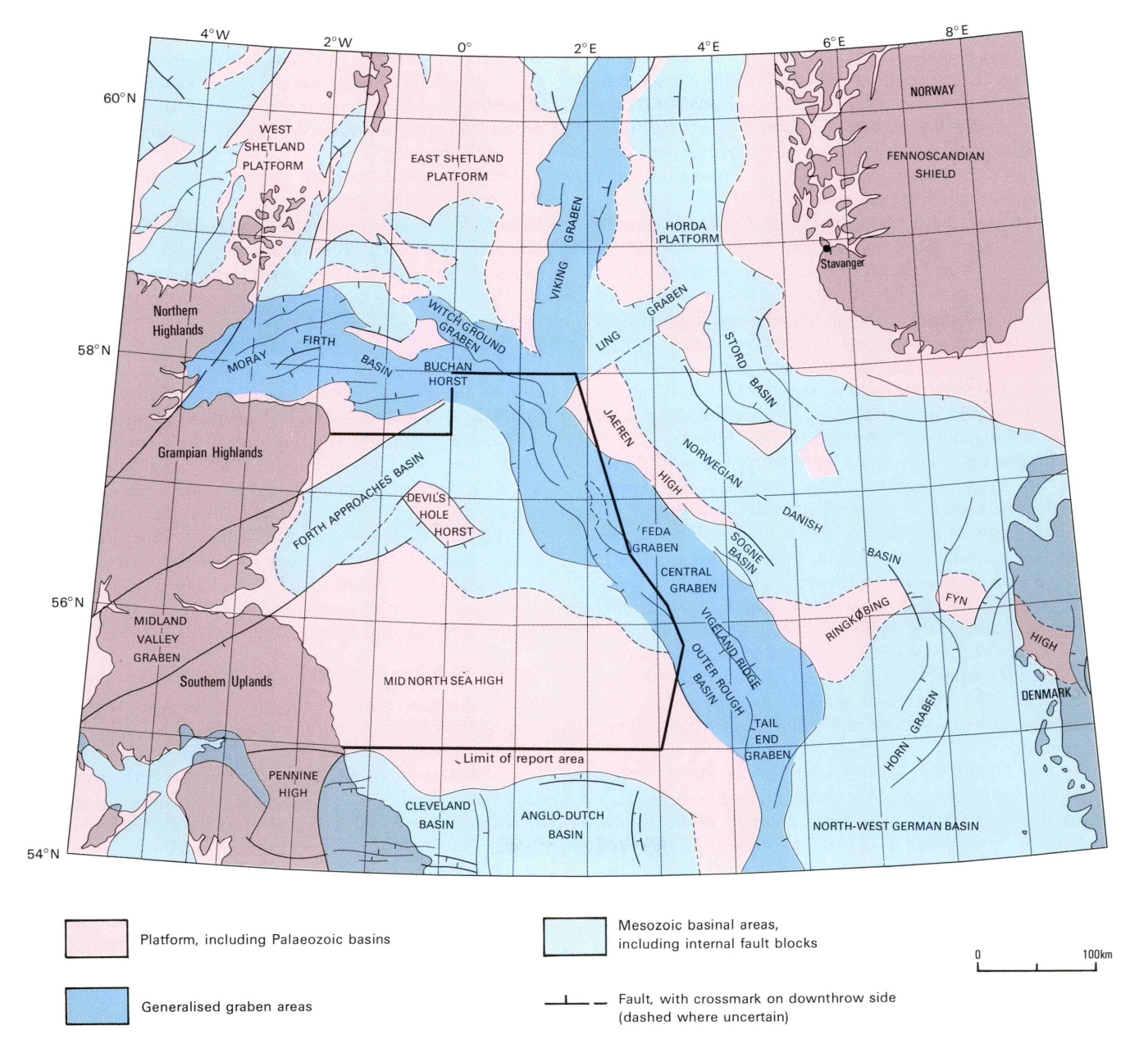
Source: https://webapps.bgs.ac.uk/Memoirs/docs/B01846.html
But there was more going on. Around 170 million years ago, an unexpected event occurred underneath the North Sea sand desert. The ground began to rise and a large dome formed. Evidence for doming has been found in Denmark, southern Sweden and east Greenland. All of these regions were close together, and a possible interpretation is a hot spot or even a minor mantle plume.
Off the Scottish coast, there is evidence for extensive volcanism which extended into the Moray Firth. The rocks have been dated to 155 million years ago, putting it at the time when the Moray Firth triple point formed. It is called the ‘Forties Volcanics’ and covers some 12,000 km2. This has led to a model where a mantle plume caused uplift and volcanism, and later initiated rifting. As the heat withdrew, the dome collapsed and the rifts worked their way towards the centre. Other models have the rifting first and the doming caused by heat pulled in by the rift. Chicken or egg – pick your preference!
The doming region became submerged again by 150 million years ago. The northern North Sea was now sea and the central North Sea was a coastal lagoon which slowly became submerged. The oxygen level was low: the sea was poorly connected to other bodies of water. This was in effect a distant arm of the Tethys Ocean, connected through the Baltic; this connection to the Tethys was often lost. The multiple continental fragments which crossed the Tethys to dock with Asia did not help.
As the Jurassic gave way to the Cretaceous, sea levels rose and the North Sea was flushed out by oxygenated waters. Scotland and Norway remained above water, but otherwise the entire North Sea and its coastal areas were submerged below as much as 500 meters of tropical sea. Chalk was deposited in thick layers. Further south, this sea had arrived earlier: here lies the origin of the Jurassic coast with we have covered in another post. The North Sea had thus far escaped. No longer.
But now the world changed again. The old continents of America and Baltica, supplemented by the more recent arrivals, began to split, along a line which ignored the North Sea rifts. The Chicxulub asteroid came and signalled the end to a way of life. The fossil record of dinosaurs in Europe used to be limited, and there were discussions whether perhaps they had died out before the impact. But fossils found in southern Europe indicate that the dinosaur diversity remained high in Europe’s archipelago right until the end, in spite of any environmental changes. But distance from the impact did not mean survival: we now know that much of the dying came from the heat radiation as debris from the impact re-entered the atmosphere across the entire world. It was death by sunburn.
After the Cretaceous came the Tertiary Paleogene. It was a time of consolidation. Sea levels rose and fell and sometimes the sea was deep, sometimes less so. The land too rose and fell. The Shetland-Hebrides region rose above sea level. Around that time the opening of the Atlantic Ocean reached this region, with volcanic action. The north of the North Sea widened. Once Greenland separated from Svalbard, around 30 million years ago, cold arctic water spread south. Water temperatures at the bottom of the North Sea dropped by 12C and warm-water fish disappeared. The Norwegian mountains were beginning to uplift some 20 million years ago. Sedimentation increased and the North Sea shallowed. And 2.5 million years ago, the climate became colder and the decline into glacial conditions started, although this would not be fully reached for another 1.5 million years. Over that time, much of the North Sea became a vast delta, a mega-Netherlands, periodically being submerged as the sea rose and fell. During glaciations, the sea was a sandy tundra.
During one of the deepest glacial periods, disaster struck. Up to this point, the North Sea had been mainly a gulf, terminating in the south at a chalk ridge. That ridge was part of a massif that runs from London to the Belgium-German border, in the old heart of Avalonia. But now a glacier had cut off the northern exit of the North Sea, leaving the glacial melt water with nowhere to go. Sea level rose and rose, finally reaching 100 meters above current level. At that point, it could overflow the chalk ridge. Chalk is not much resistant to flowing water: the ridge eroded and failed, and the North Sea suddenly emptied towards the south in a tremendous flood. Now, when the glaciers would eventually melt and the sea refilled, the barrier was gone and finally the North Sea became open at both ends. Great Britain became an island.
That is the story of the North Sea. But wasn’t there a volcano?
Zuidwal Volcano
In 1970, an oil company began with exploratory drilling in the Waddenzee southeast of the island of Vlieland, in an environmentally rather sensitive region which had been (and is again) out of bounds for oil and gas extraction. They found gas, and extraction started (carefully) in 1988 (and ended in 2021). But below the reservoir, at a depth of 2 kilometers, the seismographic reflection show the tip of a 1km-tall dome. Drilling revealed volcanic rock. It became the first actual volcano discovered in the Netherlands.
Volcanic (magmatic) rocks are known from various locations in the Netherlands, but those are intrusive rocks which did not erupt on the surface. They mostly date to the time of the Caledonian mountains. The Zuidwal volcano is different: it erupted real lava, and the lava is only 152 million years old. In spite of its considerable age, the volcano remains some 30C warmer than the surrounding rock. The Dutch being Dutch, plans were made to tap the ancient volcano for geothermal heat.
The drilling found a volcanic neck, part of the dome-like structure. The lava was trachyte-phonolite in composition, and came from a shallow magma chamber which had been filled with a mafic mantle magma.
In 1985, similar drilling 100 km to the north in the North Sea found another volcano. The existence of this volcano had already been suspected from a magnetism survey. It had been active at a similar time as Zuidwal, and had erupted a basaltic-andesitic lava. This volcano was named Mulciber, another name for the god Vulcan. Now the Netherlands had two volcanoes!
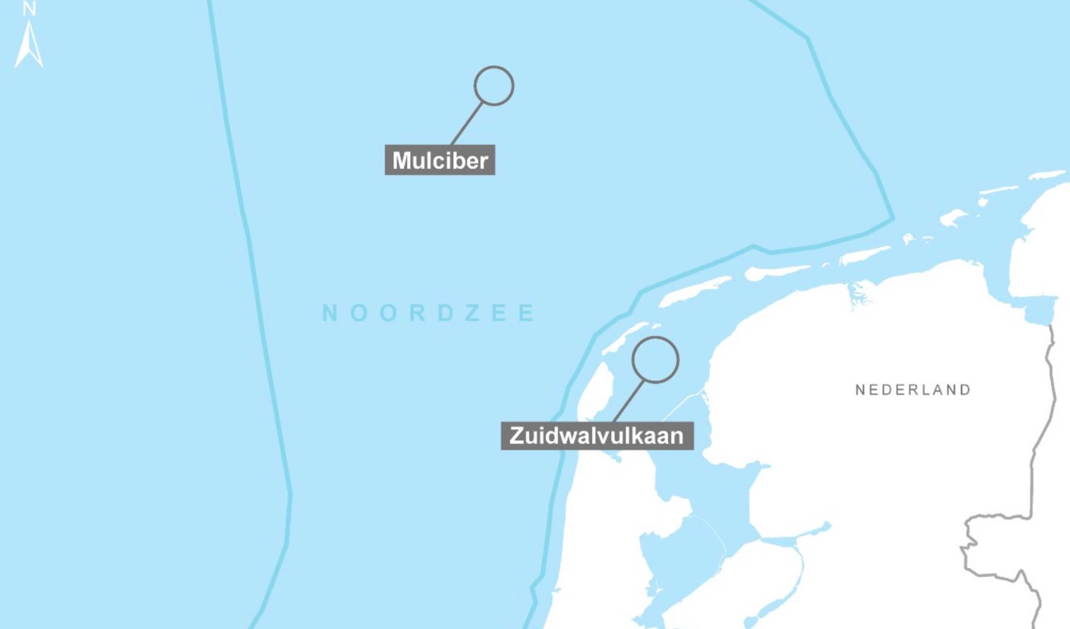
The age of these two volcanoes is similar to that of the doming in the central North Sea and the volcanics at the triple junction off the Moray Firth. They are likely associated with that phase of the formation of the North Sea. They are individual systems and not just dike extensions of a distant central volcano. But the line between them points at the triple point. Gravity highs and magnetic anomalies suggests there may be more volcanic remnants along that line, not far from Mulciber. This activity was all part of the rifting in the North Sea. This was the time when the Tethys Ocean reached into western Europe and when the Atlantic ocean first began to form. In the North Sea, everything is connected.
People of the volcano

The island of Griend
Nowadays, Zuidwal volcano lies in the Waddenzee. During Roman time, this was still mostly land. The island of Vlieland is named after the old river Vlie, which no longer exist – it was swallowed by the sea in the storms of the 13th century. The nearest island is Griend (or Gryn), also already mentioned. In the 12th century, it was home to a walled town (Stedeke Grint), with two churches, a grange (lodge) from the White Canons order and perhaps 50 houses. The town was devastated, and the island much reduced in size, in the storm flood of 1287. Over time the remaining island has migrated 3 kilometres east. A few farmers continued to live here after the town had been destroyed, but the island became abandoned in the 19th century. It is now inhabited only by birds, including the largest colony of Sandwich terns in Western Europe. Only the sea hikers (‘waddenlopers’) come here, although they are not allowed to set foot on the island itself. Do they know what lies beneath?
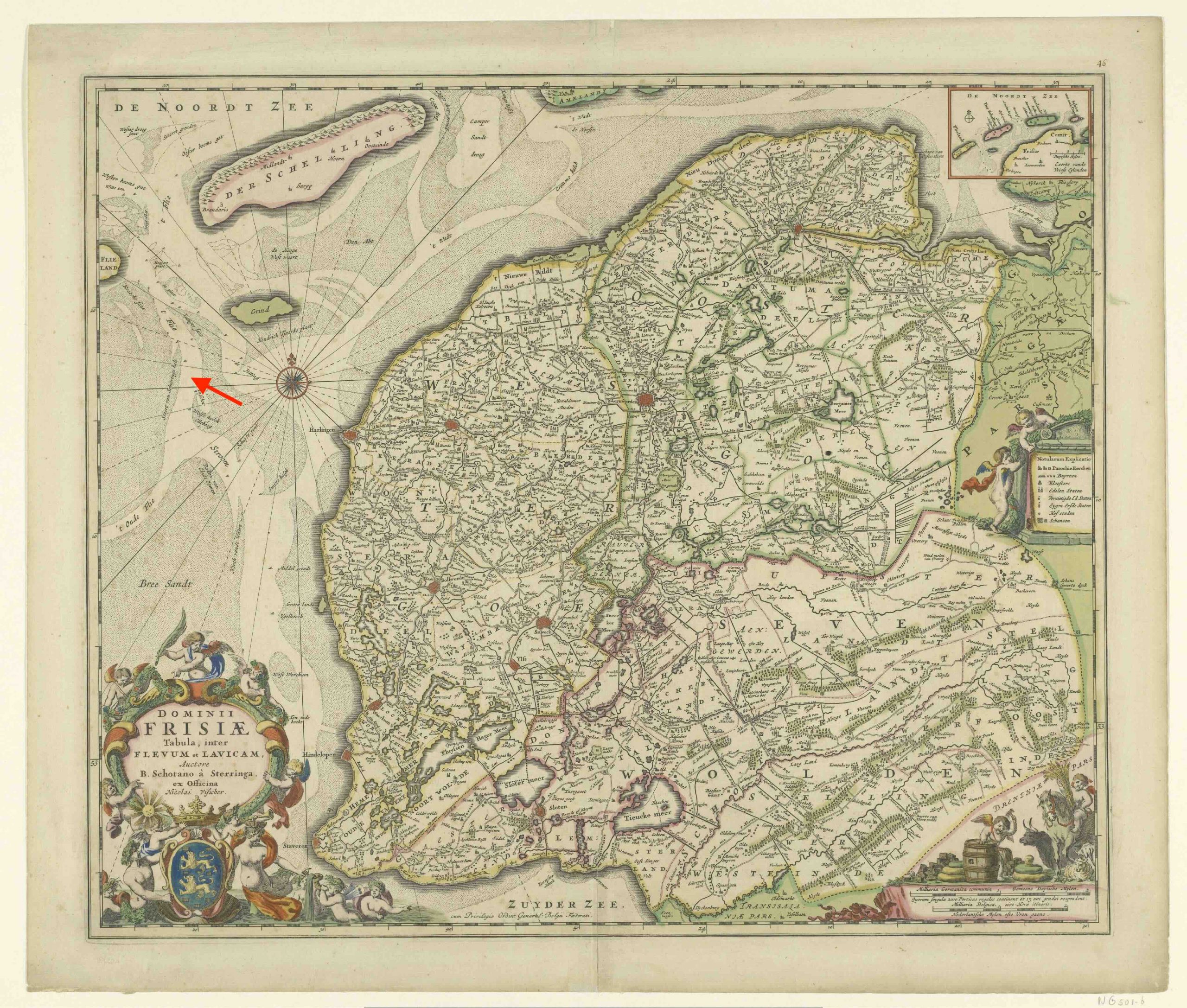
Map from around 1680 made by Bernardus Schotanus. Griend is the green island, still much larger that it is now. The arrow indicates the location of Zuidwal, within the remains of the river Vlie (written ‘Flie’ on the map).
The Zuidwal volcano that is buried here has seen it all. It was part of the origin of the North Sea, a sea that divided mountains but failed to become an ocean. It has seen the sea come and go, seen massive floods and lived through major withdrawals. And now it is part of the Waddenzee, an intertidal wetland with a fluent coast where the sea still comes and goes twice a day. Every day here is like a million years.
All lives and deaths, all of the past, present, future,
This vast similitude spans them, and always has spann’d,
And shall forever span them and compactly hold and enclose them.
(Walt Whitman, On the Beach at Night Alone)
Albert, September 2025


 English (US) ·
  French (CA) ·