

 8 hours ago
2
8 hours ago
2
PROTECT YOUR DNA WITH QUANTUM TECHNOLOGY
Orgo-Life the new way to the future Advertising by AdpathwayDisclaimer: This site is not affiliated with the National Hurricane Center, Hurricane Hunters, Storm Prediction Center, or National Weather Service. ALL forecasts herein are the result of my analysis, (to which you will see me at times, insert excerpts from various agencies due to the nature of the importance of the information) and I am solely responsible for the content. As ALWAYS, follow the National Hurricane Center, National Weather Service, and your local Emergency Management officials for emergency decisions. In addition, this is strictly a FORECAST OFFICE. I CANNOT make decisions regarding travel plans, etc. My purpose, is to provide you the information, based solely on information I analyze, and the accuracy of the information at hand of the time of analysis, so you may make informed decisions.
(T. F. “Storm” Walsh)
For those who have donated to my site, your help has been greatly appreciated. If you are not aware, donations to my site help pay for subscriptions to sites I use as well as software updates, which provide all the models and information used in my forecasts. To donate, please click the DONATE button to the right side of the page, or on the graphic of the dog. Any help you provide is immensely appreciated!
DONATIONS ACCEPTED AND APPRECIATED

I will reiterate, my forecasts are based on the available information at the time of analysis, and are only as accurate as the information analyzed and the solutions provided.
Good day everyone!
If anyone has any questions regarding tropical systems, please feel free to email me at the email address at the end of the synopsis. Please title it WEATHER QUESTION.
The following changes have been made. The forecast center is still closed on Sunday, and will be closed on Saturday as well (unless there is a threat from a tropical system). Please refer to the Storm Prediction Center for severe weather information.
SPC LINK
https://www.spc.noaa.gov/
These forecasts can be lengthy, however I want to always give a full perspective on the tropics.
STORM W SEASONAL FORECAST
TOTAL NAMED STORMS: 9 – 11
TOTAL HURRICANES : 3 – 4
MAJOR HURRICANES: 1 – 2
AVERAGE HURRICANE SEASON:
TOTAL NAMED STORMS: 14
TOTAL HURRICANES: 7
MAJOR HURRICANES: 3
2026 SEASON TOTALS
TOTAL NAMED STORMS: 8
TOTAL HURRICANES: 0
MAJOR HURRICANES: 0
The following is the list of storm names for the 2026 Atlantic Hurricane Season. Storm names will be marked in RED for active and already named systems with subtropical systems marked in PURPLE:
Arthur Bertha Cristobal Dolly Edouard Fay Gonzalo Hanna Isaias
Josephine Kyle Leah Marco Nana Omar Paulette Rene Sally Teddy Vicky
Wilfred
GOES 19 ATLANTIC IR AND WV SATELLITE LOOP 

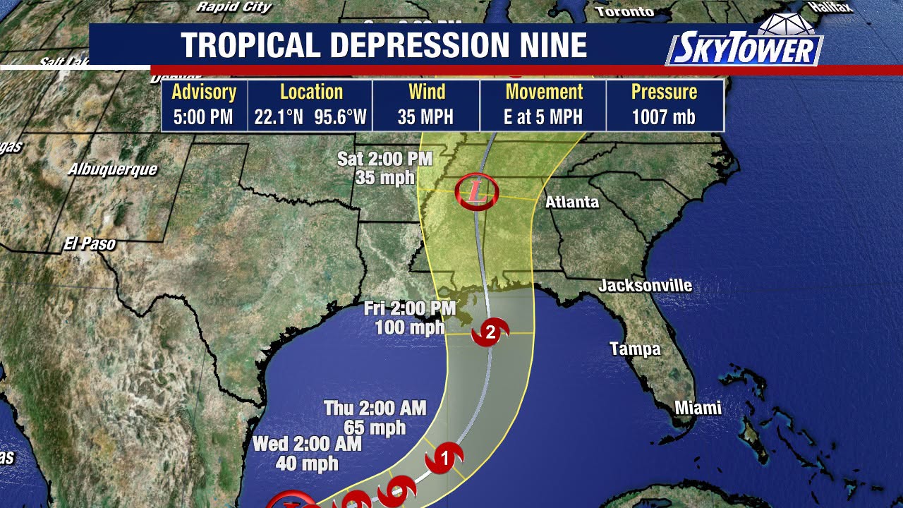
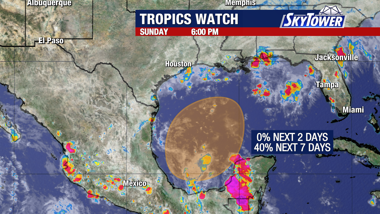
The NHC has issued a HIGH (100%) probability for cyclone development regarding INVEST 92L during the next 48 hours, and may begin issuing advisories later today
NHC 7 DAY GTWO (LINKED TO OUTLOOK)
As of the 12Z (8:00 a.m.) ATCF BTK report, the following information was available:
8:00 AM EDT Tue Oct 06
Location: 22.0°N; 96.0W
Moving: SE Drift
Min pressure: 1008 mb / 29.77 in.
Max sustained: 30 mph
The NHC Surface Analysis indicates the location of Tropical Waves
12Z NHC SURFACE ANALYSIS IMAGE
The following is the ECMWF EPS Cyclone Formation Probabilities forecast during the next 5 days.
ECMWF EPS CYCLONE PROBABILITY 24 – 72 HOURS

72 – 120 HOURS
Satellite loop imagery indicates the system continues to become slowly better organized
INVEST 92L SATELLITE LOOP IMAGERY

Based on information in the ATCF report, the system was moving at 125 degrees at 1.0 kts, which equates to a SE drift. Based on current track guidance and forecast steering layers maps, this motion should continue during the next 24 hours, before a more eastward motion takes over. Of course, this will most likely change slightly as the system becomes better organized. At the moment, I prefer the HMNI model track.
RAL 92L EARLY TRACK GUIDANCE
Analysis this morning still indicates that wind shear that was located over the center, northward, has backed off a little, and the radial pattern has become more centered over the system. Surface moisture based on PWAT analysis indicated very favorable surface moisture remains in place, and analysis of the ECMWF 700 – 500 MB relative humidity, SHIPS diagnostic report, and water vapor imagery indicates favorable moisture currently at mid level. INVEST 92L also has a well established, textbook outflow pattern based on upper level wind analysis.
CIMSS INVEST 92L WIND SHEAR
CIMSS PWAT
UPPER LEVEL WINDS
Based on analysis of the ECMWF, the radial shear pattern is forecast to remain for approx. the next 72 hours with shear beginning to increase shortly thereafter, with SHIPS indicating shear of around 26 kts. Surface to mid level moisture is forecast to remain fairly favorable up to approx. 96 hours, when some dry air intrusion may begin at the 500 mb level, with surface moisture remaining at a very favorable level.
However, the Gulf is forecast pretty much to remain within the right rear entrance region of a jetstreak in the sub-tropical jet, which provides divergence in the upper atmosphere, and could allow for an upper outflow channel to remain with the system. Based on this analysis, and CHI200 anomalies indication a moderate to strong upper divergent pattern over the Gulf, I cannot rule out continued, possibly some brief, steady intensification until the possibility of dry air becomes introduced should the current outflow pattern me maintained.
The following article explains outflow structure and rapid intensification of a hurricane. Now, I do not expect this with 92L, but it gives an idea of how a well established outflow structure can help a system overcome wind shear. This is what occurred with Hurricane Michael a few years ago.
https://journals.ametsoc.org/view/journals/mwre/149/12/MWR-D-21-0141.1.xml
So, the bottom line here at the moment is, if forecast conditions over the next few days based on modeling are correct, we could very well see at least a tropical storm. Intensity guidance has adjusted quite a bit from hurricane intensity, and this will most likely continue to adjust until this system gains a well defined low level circulation.
RAL 12Z 92L INTENSITY GUIDANCE
Regardless, this could bring copious amounts of precipitation to portions of the Gulf coast states from Louisiana, eastward.
KEY MESSAGES FROM NHC
WPC 7 DAY RAINFALL TOTAL FORECAST
Elsewhere, I do not expect any development during the next 5 days.
EXCESSIVE RAINFALL
https://www.wpc.ncep.noaa.gov/qpf/excessive_rainfall_outlook_ero.php
SIGNIFICANT RIVER FLOOD OUTLOOK
https://www.wpc.ncep.noaa.gov/nationalfloodoutlook/index.html
Please click on the following map to access the current statements, advisories and warnings from the NWS. Once you click the map, click on your area of interest.
NWS WATCH / WARNING DISPLAY (LINKED…CLICK MAP, THEN YOUR AREA)
NWS RADAR
RAP RADAR (CLICK IMAGE THEN GO TO LOOP DURATION AND PICK LENGTH OF LOOP, THEN CLICK RADAR SITE) WUNDERGROUND RADAR SUMMARY MAP (CLICK FOR UPDATES)
 PRECIPITATION TYPE (CLICK TO ACCESS ANIMATION FEATURE)
 CARIBBEAN RADAR (CLICK IMAGE TO ACCESS ANIMATION)

You may direct any questions to me by contacting me personally, ANYTIME, at: [email protected]
Have a blessed day!
T. F. “STORM” WALSH III
GMCS, USCG (ret)
METEOROLOGIST / HURRICANE SPECIALIST / SEVERE WEATHER SPECIALIST
CoCoRAHS OBSERVER
The Mechanism: The right rear entrance region features an ageostrophic wind component that pulls air northward toward the jet core, creating massive horizontal divergence aloft. [1, 2]















 English (US) ·
  French (CA) ·